Official name - Federated States Micronesia (Federated States of Micronesia).
Located in the Western Pacific Ocean. The area is 702 km2, the population is 137 thousand people. (2003). Official language- English. The capital is the city of Palikir (11.7 thousand people, 2003). Public Holiday- Constitution Day May 10 (since 1979). Currency unit- U.S. dollar.
Member of the UN (since 1991), IMF (since 1993), Pacific Islands Forum (formerly UTF, 1987).
The Federated States of Micronesia is located north of papua new guinea And Solomon Islands on 607 islands of central and eastern parts the Caroline Archipelago and the atoll of Kapingamarangi to the south. The length from the west (Yap Island) to the east (Kosrae Island) is approx. 3 thousand km.
Attractions of Micronesia
Geographical coordinates: 6°55 north latitude and 158°15 east longitude. The Federated States of Micronesia are divided into 4 parts: 1) Pohnpei - the island of the same name (the largest, 334 km2) and more than 160 islands and atolls; 2) Chuuk - 11 "high" islands in the Truk lagoon (one of the largest in the world - over 2 thousand km2) and several groups of coral atolls and islands; 3) Yap - 4 islands that make up the island of Yap (three of them are interconnected by bridges) and 15 groups of small islands and atolls; 4) Kosrae - the island of the same name and the island of Lelu, connected by a dam. Length coastline 6112 km.
Most of the islands of the Caroline Archipelago are low coral. Rain moisture does not linger in the upper layers of calcareous soils. The vegetation is adapted to saline groundwater. On the "high" volcanic islands - Pohnpei and Kosrae - the soils are rich in organic matter, the vegetation is much more diverse (areca palm, ramp, bamboo, etc.). Mangroves cover the coast of almost all volcanic islands. The highest point is 791 m (Pohnpei). Pohnpei has over 40 rivers. The animal world is represented by bats, rats, crocodiles, snakes, lizards are found. The world of birds is diverse. Yap, unlike other "high" islands, is of non-volcanic origin, it is covered with hills and meadows. The waters of coral reefs and lagoons are rich in fish and sea animals.
Minerals: the world's largest tuna reserves in the 200-mile economic zone (over 2.6 million km2), high-quality phosphate deposits and potential seabed minerals.
The climate is tropical. Temperature +23-30°С. Pohnpei Island is one of the wettest places on the planet (over 5000 mm of precipitation per year). But under the influence of El Niño, droughts occur. Destructive typhoons are regular (June-December).
The average annual population growth rate is approx. 3% per year, partially offset by emigration (about 15 thousand immigrants from the Federated States of Micronesia live in Guam, the Mariana and Hawaiian Islands, as well as in the US mainland). The vast majority of the inhabitants are Micronesians, there are Polynesians. Ethnic features are affected by long-term contacts with Europeans and the Japanese occupation. English is widely spoken, two of the 8 languages of the Malayo-Polynesian group are Chuukese (about 50% of the population) and Ponpean (25%). Each of the main parts of the country has its own culture and traditions, but there are also common features. Competently 89% of the adult population. Life expectancy for men is 67 years, for women - 71 years. Child mortality 33 people. per 1000 newborns.
Catholics - 50% of believers, Protestants - 47%, there are adherents of local beliefs.
The Caroline Islands were named in honor of the Spanish king Charles II - in 1521 F. Magellan landed here. Since 1899, the archipelago has been under the control of Germany (bought it from Spain). Japan occupied it in 1914. After the 2nd World War, 6 Pacific territories, under a UN mandate, came under the trusteeship of the United States (1947). Of these, 3 (Pohnpei, including Kosrae; Yap and Chuuk) are the current constituent parts of the Federated States of Micronesia. Since 1979, the Constitution of the Federated States of Micronesia, the national and state governments have been in force. In 1986, with the entry into force of the Treaty of Free Association with the United States, the Federated States of Micronesia became a sovereign state. In 1990, the UN Security Council abolished the status of a mandated territory in relation to the Federated States of Micronesia.
The Federated States of Micronesia is a presidential republic. The President is the head of state and government.
Administratively divided into 4 states according to geographical parts. In addition to the capital, the states have administrative centers.
Legislative power belongs to the National Congress. It has 14 senators: 4 - one from each state - are elected for 4 years (next elections in 2007), another 10 - for 2 years in proportion to the population (next elections in 2005). From the composition of the "four-year" senators, the congress elects for 4 years the president (since 2003 - J. Urusemal) and the vice president (R. Killion). By-elections are held to fill the vacancies that have arisen since then. In the election of state leaders, the informal principle of rotation between the states operates. Each of the 4 states of the country has a similar structure of executive and legislative power in accordance with its own Constitution. State governments exercise most of the executive functions in the state.
There are no political parties.
Under the Treaty of "free association" with the United States, the latter carry out the defense of the Federated States of Micronesia.
The Federated States of Micronesia have had diplomatic relations with Russia since 1999.
GDP per capita approx. 2 thousand US dollars. GDP growth rates since ser. 1990s - 1-2% per year. Agriculture retains a semi-natural character. Its value is declining. It employs up to 50%. The rest work in the public sector, retail and tourism industries. Unemployment - 15-20%.
Coconut palm, betel, cassava, tropical fruits and vegetables, sweet potatoes, black pepper are grown, poultry and pig farming, fishing and fish processing are developing. Souvenirs are made from shells, wood and pearls.
Automobile roads - 240 km (42 km - with a hard surface). In each of the 4 city centers - international Airport, capable of receiving medium-range aircraft, and a deep-water port accessible to ocean-going vessels. In the Federated States of Micronesia - 2 thousand Internet users (2000).
Up to 15 thousand tourists visit the islands annually. Remoteness and lack of infrastructure hinder the development of tourism, but the Asian Development Bank considers this industry the most promising.
The Federated States of Micronesia is heavily dependent on US financial assistance. According to the Agreement on "free association" in 1986-2001, it amounted to approx. $2 billion in grants and subsidies. Since 1999, negotiations have been underway to extend the Treaty. Aid has been extended for the duration of the negotiations, but has been declining in recent years, affecting the economic situation of the Federated States of Micronesia.
In addition to fish and fish products (85% of exports), copra and coconut oil, black pepper, bananas, etc. are exported. Imported foodstuffs and drinks, finished products, equipment. The main partners are the USA, Japan, Guam, Australia. Up to 30% of budget revenues come from the sale of licenses to foreign fishing vessels.
Primary (eight years) public education is compulsory (but 25% of children do not attend school). There are 2 (private) secondary schools, Marine and Fisheries Academy (secondary and college level). The College of Micronesia (Pohnpei) provides higher education.
The content of the article
MICRONESIA, The Federated States of Micronesia (FSM), a state in the northwestern part of Oceania between 0 and 14 ° N. latitude. and 136 and 166°E (2500 km from west to east), occupies 607 islands of the Caroline archipelago (except for the islands of Palau, or Belau, in the west). Consists of four states: Yap, Chuuk (formerly Truk), Pohnpei (formerly Ponape) and Kosrae (formerly Kusae). The total land area is 702 sq. km. (including Pohnpei 0.34 thousand sq. km., Chuuk 0.13 thousand sq. km., Yap 0.12 thousand sq. km., Kosrae 0.12 thousand sq. km.). Only 40 islands are significant in size. The largest of them are islands with the same names as the states. The capital is the city of Palikir on the island of Pohnpei.
NATURE
By geological structure distinguish between low coral islands, rising 3–5 m above sea level, and higher volcanic ones (Yap, Chuuk, Pohnpei, Kosrae), with elevated mountainous central parts. Volcanic islands are surrounded by lagoons, separated from the ocean by coral barrier reefs, often consisting of several dozen small islands. Many reefs have passages that allow ships to approach large islands.
Yap State includes seven small and four large islands (Yap, Map, Rumung, Gagil-Tomil) and 134 atolls, spreading from west to east for 1100 km. Yap Island is characterized by a hilly terrain with a maximum height of 178 m (Mount Tabiwol) and fertile soils. He is surrounded barrier reef. Most of the population of the state of the same name lives on the island of Yap. The state capital is the city of Colonia. The largest atoll of the Caroline Islands, Uliti Island (8 sq. km), consists of 40 small islands. The Fais atoll in the Yap group is known for its phosphorite reserves.
Chuuk State, which occupies a central position in the FSM, is located 1440 km east of Yap Island and consists of 15 small island groups scattered in the waters of the Pacific Ocean over a distance of 480 km in a latitudinal direction in the north and 960 km in the south. The state also includes the atolls of Namonuito (the second largest in the world), consisting of 10 islets, Namoluk (triangular), Laol, Pis, Talap, the islands of Pular, Puluwat, Kuop, Nama, Losap, Mortlock (100 islands in three groups - Ethal, Lukunor and Satavan). The Chuuk Islands proper is a compact group of 14 mountainous islands of volcanic origin (Moen, Tol, Dublon, Fefan, Uman, etc.) with total area 72 sq. km, surrounded by a coral reef. Main city Chuuk Moen state is located on the island of the same name. The lagoon surrounding the 14 central islands of the Chuuk group with an area of 2000 sq. km, serves as an excellent harbor for the port on the island of Dublon. The settlements are confined to the coasts of the islands.
Pohnpei State occupies the eponymous most large island, surrounded by a reef consisting of 2.5 dozen islets, half of which are of volcanic origin. The state also includes the islands of Ant (2 large and 12 small), Pakin, Oroluk (with small islets), Mokil (the islands of Urak, Manton, Mokil with excellent timber and several hundred small ones), Pingelap (Pingelap proper, Takai and Tagulu , united by one reef), as well as two isolated atolls, Nukuoro and Kapingamarangi (also known as Greenwich).
The soils of Pohnpei are fertile, lush forest vegetation covers the slopes rising straight from the shores up to Mount Nana Laud (798 m), located in the center of the island. Numerous rivers originate from it - sources of drinking water. On this island is the capital of the state of Palikir with the residences of the government and congress, a modern airport and sea port. The state capital is the city of Colonia.
The state of Kosrae is located on the island of the same name and the surrounding reef in the extreme east of the FSM. The island is mountainous with a strongly dissected relief (the most high point- Mount Fincol, 634 m above sea level), covered with thickets of excellent timber forest. The soils are fertile. There are significant reserves of river drinking water. Kosrae Island is surrounded by a reef, there are four convenient bays (Okat, Lelu, Taf and Utwe). The main settlements - Tafunsak, Lelu, Malem and Utwe - are located on the coast and are interconnected by an unpaved road. The capital city of the state is Lelu. There is a local air connection with o.Pohnpei. The airport is operational.
The climate of FSM is equatorial, more humid in the east of the archipelago, where the zone of cyclones passes. Conventionally, two seasons are distinguished: dry (January - March) and wet (April - December). From November to December, the northeast trade winds prevail, the rest of the year, southwest monsoon winds blow, bringing heavy rainfall. Pohnpei has an average of 300 rainy days a year. The average annual rainfall is 3000–4000 mm. Seasonal fluctuations in air temperature are insignificant, the average monthly temperatures are 24–30 ° C. The length of daylight hours is the same throughout the year.
The vegetation is represented mainly by virgin moist equatorial forests on the slopes of the mountains. On volcanic islands, it is much more diverse than on coral ones. The coasts of volcanic islands are often covered with mangroves. On the islands of both types grow coconut palm, breadfruit, pandanus, bananas. Europeans and Asians introduced citrus fruits, cassava, sweet potato, various tropical fruit trees, chocolate tree, and black pepper.
The land fauna is not very diverse. Bats, rats (brought on ships by the first Europeans), lizards are represented. Many kinds of birds. Extremely varied and rich animal world ocean, including many species of fish, crustaceans, bivalves, dolphins, whales and dugongs are sometimes found.
POPULATION
As of July 2003, the FSM had a population of 108,143. The age composition of the population: under 15 years old - 38%, aged 15 to 64 years old - 59%, over 65 years old - 3%. The average life expectancy is 69.13 years. Population growth in 2003 was 0.04%. The birth rate reaches 26.47 per 1000 inhabitants, the death rate is 5.1 per 1000. The emigration rate is 20.98 per 1000. Infant mortality is 32.39 per 1000 newborns.
The "free association" agreement with the United States allows citizens of the country to freely choose their place of residence within the United States. At the present time in the USA (on the island of Guam, the Hawaiian Islands and on the mainland) approx. 15 thousand FSM citizens.
The ancestors of the modern inhabitants of the Caroline Islands come from South-East Asia. In racial terms, they form a special group, formed as a result of a mixture of Australoid and Mongoloid elements. The atolls of Nukuoro and Kapingamarangi are inhabited by Polynesians. In ethnic terms, 9 groups are distinguished.
The official language of the FSM and the language of international communication is English. The indigenous languages of the archipelago belong to the East Oceanic group of the Oceanic branch of the Austronesian family: Yap, Woleai, Uliti and Sonsorol, Caroline, Truk, Kosrae, Nukuoro and Kapingamarangi. The last two belong to the Polynesian languages. The writing of local languages is based on the Latin script. Many older people speak Japanese.
50% are Catholics, 47% are Protestants, less than 1% of the population adheres to local traditional beliefs.
Ethnic composition and employment.
The ancestors of the modern inhabitants of the Caroline Islands come from Southeast Asia. According to the latest theories, Micronesia was settled in two ways - through the islands of the Malay Archipelago, and possibly the Japanese Islands, and also through Vanuatu (former New Hebrides). The inhabitants of the Caroline Islands, like all Micronesians, racially form a special group, formed as a result of a mixture of Australoid and Mongoloid elements. They are characterized by rather dark skin, wavy, straight and curly hair, and medium height. In the appearance of some Carolinians, there are also Japanese, Chinese and European features. The atolls of Nukuoro and Kapingamarangi are inhabited by Polynesians.
The traditional occupations of the local population are fishing and farming. Small areas of the forest cleared from the forest are used for the cultivation of coconut palm, breadfruit, pandanus, yams, sweet potatoes, cassava, bananas, taro, sugar cane. Currently, citrus fruits, various fruits (pineapples, papaya, mangoes, etc.), chocolate tree, pepper (black and betel) are also grown. The population is also engaged in fishing and collecting shellfish and crustaceans on the reef. In recent years, employment in the tourism business (hotels, restaurants, agencies) and airports has been growing. In the cities, Carolinians work as petty employees and are engaged in handicrafts, in particular, the manufacture of souvenirs.
Language and writing.
The official language of the FSM is English, which is also the language of interethnic communication. The indigenous languages of the archipelago belong to the East Oceanian group of the Oceanian branch of the Austronesian family - Yap, Woleai, Ulithi and Sonsorol, Caroline, Truk, Kosrae, Nukuoro and Kapingamarangi. The last two belong to the Polynesian languages. The writing of local languages is based on the Latin script. English is taught in all schools. Many older people speak Japanese.
Religion.
The overwhelming majority of the population professes Christianity, and there are approximately equal numbers of Catholics and Protestants. Protestants predominate in some states (over 98% in Kosrai), in others - Catholics (Chuuk state). Less than 1% of the population adheres to local traditional beliefs.
POLITICAL SYSTEM
The FSM is a democratic, federal presidential republic in a "free association" relationship with the United States. The head of state and government is the president. Like the Vice President, he is elected by Congress from among its members for a term of four years. In 2003, Joseph John Urusemal was elected President of Micronesia.
The highest legislative body is the National Congress, which consists of 14 members. 4 of them (sometimes called senators) are elected by the population for 4 years (one from each state), the remaining 10 - for 2 years in single-member districts (5 in Chuuk, 3 in Pohnpei, 1 each in Yap and Kosrae). The last elections took place in 2003. The minimum age for participation in elections is 18 years.
Each of the 4 states has a governor and a legislature elected by the people.
There are no official political parties.
The highest judicial body is the Supreme Court.
The FSM is a member of the UN (since 1991) and its specialized organizations, as well as a number of regional organizations, such as the Pacific Forum.
There are no own armed forces. According to the agreement on "free association", the country's military protection is provided by the United States.
ECONOMY
Micronesia's economy is based on subsistence and semi-subsistence agriculture and fishing. There are few minerals on the islands, except for phosphates. There is significant potential for the development of the tourism industry, but the remote location, lack of developed infrastructure and an established system of transport links hinder it. The private sector is growing slowly.
After the value of GDP reached $145 million in 1989, it declined in subsequent years and in 2002 was estimated to be around $100 million, or approx. 2 thousand dollars per capita. Real GDP growth in 2002 reached 1%. Agriculture provided 50% of the value of GDP, industry - 4%, services - 46%.
The inflation rate in 2002 was 1%. OK. 28% of the population lives below the official poverty line. Two-thirds of the wage labor force works in the public sector. Unemployment in 1999 reached 16%.
Agriculture provides 60% of the country's food needs. Nearly 50% of the working population all year round or during agricultural work. They grow coconut palm, breadfruit, pandanus, yams, sweet potato, cassava, bananas, taro, citrus fruits, papaya, mango, chocolate tree, pepper (black and betel) and other crops. Goats, sheep and buffalo are bred on Pohnpei. Some agricultural products are exported, mainly coconut products. The coconut palm, its leaves and nuts are the main food of the islanders. In recent years, the role of fishing has increased in the country's economy, since the resources of the ocean within the maritime economic zone (2.6 million square kilometers) are its property. Licensed fishing is carried out by Japan, Taiwan, South Korea, Mexico and USA. The Micronesian Maritime Academy operates on Yap, which trains personnel for the development of fisheries.
Foreign tourism is developing. Every year the country is visited by approx. 25 thousand tourists, mainly from Australia and Japan. The industry is dominated by construction, fish processing, aquaculture, the production of handicrafts and souvenirs from shells, wood and mother-of-pearl.
The main export items are copra (more than 50% of export value), pepper (black and betel), fish (mainly tuna), trochus shells, coconut derivatives (edible and cosmetic oils, soaps, creams), bananas, local handicrafts. The export volume is 73 million dollars per year. Goods are exported primarily to Japan, the USA and Guam.
The value of imports is estimated at $168 million (1996). FSM imports up to 40% of food products, manufactured goods, cars and other machines, oil products. Main import partners: USA, Australia and Japan.
Total length highways- 240 km., of which 42 km. have a hard coating. The main ports are Colonia (Yap), Colonia (Pohnpei), Lele, Moen. In 2002, there were 7 airports, of which 6 were paved.
Micronesia has 11 thousand telephone lines and 2 thousand Internet users, 6 radio and 2 television stations. The population owns 9.4 thousand radios and 2.8 thousand televisions.
The budget consists of taxes, exports of agricultural products, seafood, licensing of tuna fishing by foreign states in the maritime economic zone. Financial assistance from the United States helped to cover the excess of expenses over income. In accordance with the agreement on "free association", in 1986-2001 the United States provided financial and technical assistance in the total amount of 1.3 billion dollars. By agreement in 2002, this assistance was significantly reduced. External debt 53.1 million dollars. Monetary unit - US dollar.
SOCIETY AND CULTURE
Education.
According to the FSM constitution, education is financed from the central and regional budgets. Primary and secondary schools are owned by the state and religious missions. State governments provide primary education and teacher training, while central governments support and coordinate education at all levels. Young people receive vocational education at the Micronesian College in Palikir (opened in 1972, it has faculties of business, pedagogy, applied arts, etc.), the Micronesian vocational center on the island of Kosrai, at the schools of agriculture and trade on Pohnpei, the Javier Higher School on Chuuk, and also in US educational institutions (on the mainland, Guam and the Hawaiian Islands).
Healthcare.
Medical assistance to the population is carried out in full by state medical institutions. True, in recent years, a private dental and medical practice has appeared on Pohnpei Island. The FSM government recruits doctors for the Public Health Program through the US National Health Service and the United Nations Development Program. It also runs various health, nutrition and sanitation programs from the World Health Organization (WHO), the United Nations International Children's Fund (UNICEF), and the South Pacific Commission (STC). There are hospitals in every state, several dispensaries and more than 100 dispensaries operate in the country. In difficult cases, patients are sent to hospitals on the island of Guam and the Hawaiian Islands.
Culture.
The traditional culture of the FSM population is all-Micronesian (with the exception of the culture of the two Polynesian atolls of Nukuoro and Kapingamaranga). However, it has undergone significant changes over several centuries of foreign domination. But even at present, on many islands, there are houses of local pillar construction without walls, the function of which is performed by gable roofs that reach to the ground, covered with palm leaves or mats. Micronesians still master the art of making wooden boats without a single metal nail. Leaders play a significant role in the public life of the FSM. Perhaps the culture of the Yap people remained the most conservative (folklore, dances, houses on stone foundations under palm leaves, loincloths for men and puffy skirts made of vegetable fibers for women).
Intensive contacts in recent decades with Western world changed the mentality of the young generation of FSM citizens, who are no longer guided by traditional values, but strive to join the achievements of Western civilization.
STORY
The ancestors of the Micronesians settled the Caroline Islands more than 4 thousand years ago. Over the centuries, two social groups have developed in Micronesian society - "noble" and "simple"; the former did not engage in physical labor and differed from the latter in special tattoos and decorations. At the head of the territorial associations were leaders (tomol), but their power was not the same on different islands. Remains found on Temen Island (Pohnpei State) ancient civilization The stone city of Nan Madol. It consisted of monumental structures erected on reefs - platforms built of coral rubble and lined with basalt slabs. Residential and temple complexes, buried the dead and performed various rituals. According to legends, the city was the center of the vast Saudeler power and was destroyed by the conquerors, after which Pohnpei broke up into five territorial entities. Similar monuments were found on Lelu island (Kosrae state). On the island of Yap in later times, apparently, there was a centralized state formation, which had economic and religious functions. Tribute was collected from conquered tribes. The first Europeans found on Yap one- and two-tier platforms with temples and men's houses, as well as original money in the form of large stone disks with a hole in the center.
The Caroline Islands were discovered by European navigators in the 16th and 17th centuries. In 1526 di Menezighi discovered the Yap Islands, and in 1528 Alvaro Saavedra first saw the Truk Islands (modern Chuuk). In 1685, Captain Francisco Lazeano again discovered the island of Yap and named the island Caroline (after the king of Spain, Charles II). Later, this name was transferred to the entire archipelago, which was declared the possession of the Spanish crown. However, the discovery of its islands continued in subsequent years. The first Spanish Catholic missionaries, who arrived in 1710 on the Sonsorol Islands and in 1731 on the Ulithi Atoll, were killed by the islanders, and the Spanish abandoned their attempts to colonize the Carolines until the 1870s.
From the end of the 18th century the archipelago began to be visited by commercial and scientific British, French and even Russian ships. So, in 1828, the Russian navigator F.P. Litke discovered the islands of Ponape (Pohnpei), Ant and Pakin and named them in honor of Admiral D.N. Senyavin. Since 1830, American whalers have often come here. In the 1820s and 1830s, British sailors lived on Pohnpei, shipwrecked while carrying an English missionary on Kosrai. In 1852, American evangelists founded a Protestant mission on the Pohnpei and Kosrae islands. German and English traders began to penetrate the archipelago.
In 1869, Germany founded a trading station on Yap, which became the center of the German trading network in Micronesia and Samoa. In 1885, the German authorities announced their claims to the Caroline Islands, which Spain considered its own. Thanks to the mediation of the Pope, a German-Spanish treaty was concluded, recognizing the archipelago as Spanish possession, but giving German merchants the right to establish trading posts and plantations on them. Spanish soldiers and missionaries arrived on the islands, but they met fierce resistance on Pohnpei. The islanders rebelled and destroyed the plantations.
After the defeat in the war with the United States, Spain in 1898 agreed to cede the Caroline and Mariana Islands to Germany. From 1906 they were ruled from German New Guinea. The German colonial authorities introduced general labor service for adult islanders and began extensive road construction. In response, the people of Pohnpei rebelled and killed the governor of Beder. The uprising was crushed by the German fleet only in 1911. In the autumn of 1914, Micronesia was occupied by Japanese troops.
Japan officially received a League of Nations mandate to govern Micronesia only in 1921. It used the territory of the Caroline Islands in economic purposes(fishing, production of flour from cassava and alcohol from sugar cane), to establish naval and air bases. In relation to the indigenous population, Japan pursued a policy of forced assimilation. Tens of thousands of Japanese were resettled on the islands, who were given the best lands. There were Japanese settlements. Traces of Japanese domination are preserved in the appearance of the Carolinians, in their language and names.
Since 1944, bloody battles began on the islands between American and Japanese troops. By 1945, Japanese forces were expelled from Micronesia, the archipelago came under the control of the US military authorities, and in 1947 the Caroline Islands (together with the Marianas and Marshalls) became a United Nations Trust Territory administered by the United States - Trust Territory pacific islands(PTTO). In 1947-1951, the territory was under the jurisdiction of the US Department of the Navy, then it was transferred to the control of the civil administration of the US Department of the Interior. In 1962, administrative bodies were transferred from the island of Guam to the island of Saipan (Marian Islands). The Council of Micronesia was created in 1961, but all power remained in the hands of the American High Commissioner. In 1965, the first elections to the Congress of Micronesia were held. In 1967, Congress created the Commission on the Future Political Status, which recommended seeking independence or establishing "free association" relations with the United States with full internal self-government. Since 1969, negotiations have been held between representatives of the Congress of Micronesia and the United States.
On July 12, 1978, the population of the districts of Truk (Chuuk), Ponape (Pohnpei), Yap and Kusaiye (Kosrae) voted in a referendum for the creation of the Federated States of Micronesia. The Marianas, Marshall Islands and Palau refused to enter the new state. On May 10, 1979, the FSM Constitution was adopted, and in the autumn the first elections were held for the National Congress, as well as for the governors of four states. The former president of the Congress of Micronesia, Toshivo Nakayama, took office in January 1980.
During 1979–1986, the United States consistently transferred administrative functions to the new head of state and government. FSM foreign policy and defense issues remained the prerogative of the United States. In 1983, the population in a referendum approved the status of "free association" with the United States. On November 3, 1985, the PTTO was officially dissolved and the US Trusteeship regime ended. On December 22, 1990, the UN Security Council approved the abolition of guardianship and the FSM became officially an independent state.
Micronesia in the late 20th - early 21st century
In 1991, President of Micronesia John Haglelgam (1987-1991), who lost the parliamentary elections, resigned as head of state. Bailey Olter (Pohnpei State) held the presidency from 1991-1996, Jacob Nena (Kosrae State) from 1996-1999, Leo Ami Falkam from 1999-2003, and Joseph John Urusemal from 2003. A draft constitutional amendment providing for the direct election of the president and vice president was rejected.
The country's main problems remain high unemployment, declining fish catches and a high degree of dependence on US aid.
» Truk, Federated States of Micronesia
There is nothing cooler than an evening on a good Micronesian island: with white sand, almost even without the usual marine debris, with palm trees with coconuts removed so that a tourist does not fly over the head, with a beautiful sunset promising tomorrow's adventures. The repellent does not cope well with mosquitoes, but this is not visible in the photo.
Mornings are even more beautiful. We are divers in a diving hotel in one of the most important dive sites. 
A good Micronesian island of the day is Truk, until 1944 the largest naval base of the Japanese in the South pacific ocean, and now the world mecca of diving to sunken ships and planes. 
Truk
From a dive hotel with a closed area with grass and palm trees, you can and should only go to the sea, but we take a car and drive around Truk, and Truk is absolutely beautiful.
Independent since 1986, but the postal code system is still American: 
On the shield on the left is the heavenly Truk, which is in the heads and hearts (it is worth noting the marked asphalt roads, the garbage removed and the mowed lawn. Nobody drinks), on the right is Truk, our days: 
The real deal is this: Truk is not an island, but a lagoon in which several islands are approximately the same size. We are not going around Truk, but around Weno - an island with an airport, all business and tourists. Veno - and the island, and the city, and the capital of the state, and the village, gradually turning into each other. 
Veno
The main road: 
Veno fights for the title of the owner of the worst main road around the island in Micronesia, but loses the main one: there are an insane number of holes on Tarawa and you drive nervously like a grater, on Truk the holes have already merged into a single semi-flooded kind of channels and the ride has become calmer. 
The main road narrowed, how to miss school bus american style? 
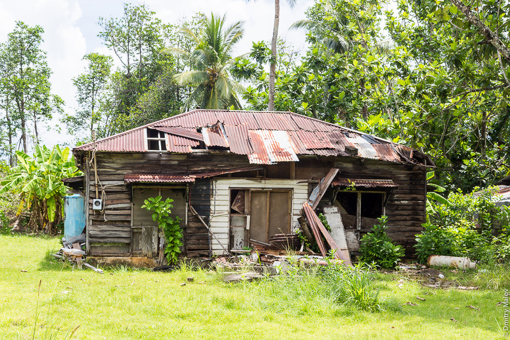
The jungle is gradually digesting the machines and units that have not coped with the Truk road: 

But in much better condition. 
Village. 

A man walking towards him with an empty bucket, as it were, hints: 
Good-natured locals hang out. Good nature ends with sunset: Truk is the most dangerous, most vile place. Micronesians have the same problems with alcohol as some of the aboriginal peoples, the Indians, the inhabitants of northern Siberia, but alcohol is not limited by anything other than church propaganda, and by the evening fights begin, robbery of wealthy strangers or worse. 
Buried in the yard, if the site allows: 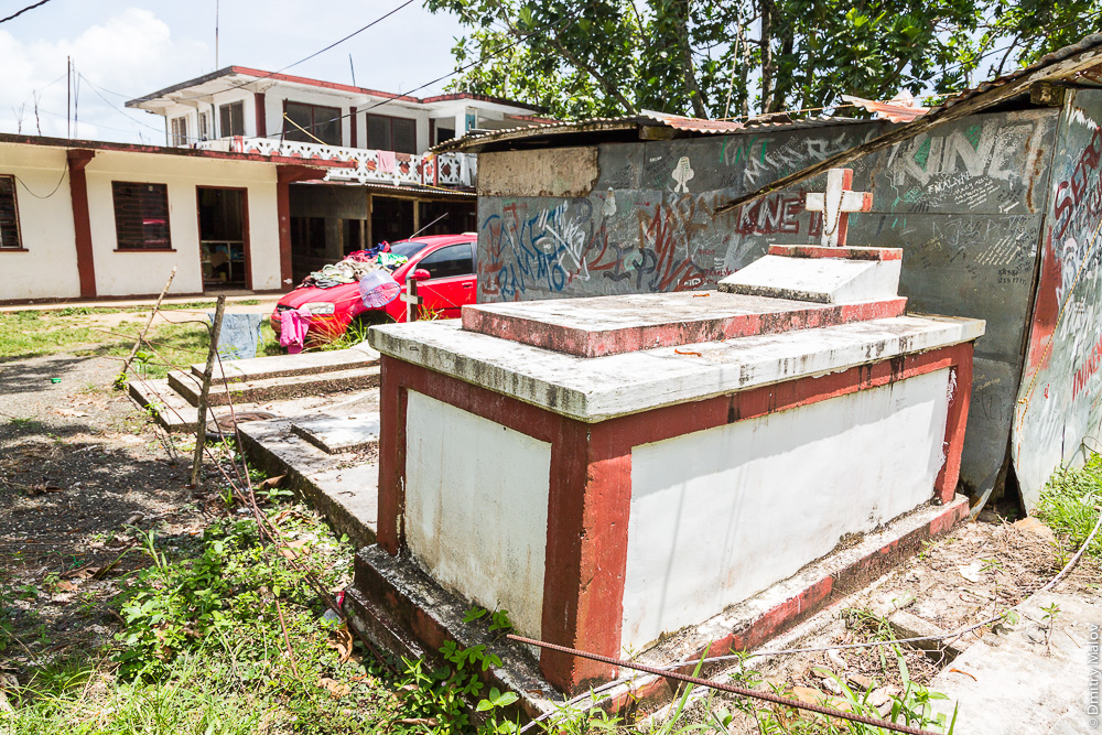
The young man stands under a canopy and hides his hands: 
Stretched fiber-optic communication line: 
The young man was carrying coconuts, got tired and sat down: 
The girls are posing 
Soft borders: 
There are very few historical houses of European and Japanese colonists left, but they are insanely beautiful: 

Here are the churches, as in everywhere, in in large numbers and in perfect order: 
Turtle over the gate - straight from pre-European history, when public halyards were decorated with something cool, like drawings (or skeletons) of useful marine inhabitants. Actually, the churches of our time usually stand on the site of the temples demolished by the first missionaries. 

Sometimes the main road emerges from the jungle village and winds along the crystal-turquoise waters of the lagoon 
So that the diver does not forget why this is all for him, from each car number, T-shirts and souvenir remind:


