On this page:
Cape Besov Nos of Lake Onega is widely known in narrow circles as a place that every self-respecting jeeper should visit. Dozens of real men every summer storm the Onega forests and swamps in unison. In other circles, Besov Nos is famous mainly for its Neolithic petroglyphs, which we went to (more precisely, sailed) to see.
A trip to Besov Nos has become a byword among fans of off-road shit climbing. The very first pictures for the query “demons nose on a jeep” in Google are beautiful:

No, it didn't break, it's his suspension.

Well, etc. and so on. No, this is not our car =))

This fascinating pastime is best characterized by a dialogue read in some report:
Why do you need so much gasoline?
- Yes, our motorboat turned over, all leaked out.
How did it turn over?
- Yes, I collided with the UAZ and rolled over.
We have no more questions.
Particularly gifted people drive right along the banks of the Onega to the Murom Monastery - this is a new chic. It's even more interesting:

Although we accidentally had a jeep with us for all jeeps, it was not at all prepared for such swims. So, as the last suckers, they had to sail on the same motorboat. In principle, you can also walk to Besov Nos on foot, along the jeep road to the place is only 15 km.
How to get to Besov Nos
All roads to Besov Nos start in the village of Karshevo, about 40 kilometers south of Pudozh. Half of the population of this village trades in the delivery of everyone to Besov Nos on motorboats.

It costs an average of 1000 rubles. from a person.

Sailing along the river is quite far, about half an hour one way.


Finally, the river flows into the Onega, and we shake ourselves out of the boat.

From the mouth of the river to the actual Cape Besov Nos, you still need to walk three kilometers along the sandy beaches of Onega.

On the high capes, the entire pine forest was broken by the 2010 hurricane. From it, throughout the North, there were areas of literally mowed forest.

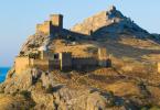
Devils Nose
Here, finally, is the Devil's Nose.

It is a granite "foreheads", gently descending into Onega. On this granite and you need to look for petroglyphs.
The most famous of the local petroglyphs is the so-called "bes": its legs are clearly visible in the photo below.

And the rest is poorly visible, because the weather turned out to be cloudy and unsuitable for looking at petroglyphs.

For good reason, you need to go to Besov Nos in sunny weather: in the light scattered by clouds, petroglyphs are very poorly visible. And a local guide will not hurt: some drawings are difficult to find without outside help.
This is how the Bes looks like if you draw its outlines with chalk.

It can be seen that the figure was carved over a large crack that split a granite boulder. Perhaps the ancient natives considered this crack to be something like an entrance to other worlds.
In general, despite the fact that Besov Nos is the largest “deposit” of petroglyphs in all of Fennoscandia (Scandinavia, Finland and Karelia), the Onega petroglyphs are very poorly studied, almost completely undeciphered, and it is not really known who and why all this was knocked out in stone in the era Neolithic.
To the right, an Orthodox cross is carved on top of the Bes. This is the work of the monks of the nearby Murom Monastery, who actually discovered the Onega petroglyphs a couple of hundred years ago.
Well, around Bes there are many other drawings of animals, fish and incomprehensible figures.


Previously, a lighthouse worked on the cape, now in the era of GPS, no one needs it and is abandoned.

And all around are untouched pine forests. The places are simply magical and of course you need to go here for a week or two with a tent, and not for a couple of hours.

Peri Nose
There are petroglyphs not only on Cape Besov Nos itself, but also on neighboring ones. The nearest of them is Cape Peri Nos, a kilometer away. We go there along the coast.

On the way, we refresh ourselves with pasture. What I like in the north is that all the “gifts of nature” grow there at once: in the forest there are raspberries, blueberries, lingonberries, blueberries, cloudberries, and mushrooms at the same time. Cranberries, however, later.


Peri Nos is a few stone headlands protruding into the lake, which also have petroglyphs.

Here the plots and style are different and nothing is clear at all. Who is this? Some birds.

Lots of simple icons and geometric shapes.


Our boatman gave us 3 hours for everything, and this was not enough. We haven't seen everything yet, but we already have to go back.
Besov Nos is a cape on the eastern coast of Lake Onega, 1.5 km north of the confluence of the Chernaya River into Lake Onega.
General information
The cape is famous for its petroglyphs, among which stands out an anthropomorphic image called a “bes”, about 2.30 m long, which is about 5 thousand years old. The name "demon" was given to the image by Christian pioneer monks in the 16th century. Petroglyphs are classified as archaeological Neolithic monuments. The collection of petroglyphs at Cape Besov Nos is considered the richest in Fennoscandia (Scandinavia and Finland).
Approximately 200 meters from the cape to the west in the lake there is a small rocky island called "Besikha".
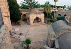
There is a non-working lighthouse on the cape. 1 km east of the cape, on the continent, there are the remains of the abandoned village of Besonosovka. The village ceased to exist in the late 1960s and early 1970s. 15 km to the east on the continent is the village of Karshevo. Besov Nos is connected to Karshevo by a dirt forest road.
Approximately 1 km north of Besov Nos is Cape Peri Nos. At the same distance to the south is Cape Kladovets.
Cape Besov Nos and adjacent capes - is a familiar place for local fishermen and hunters to visit - from the village of Shalskoye - 20 km to the north along the coast of Lake Onega and from Karshev.
For decades, Besov Nos has been the goal of constant expeditions of archaeological units of the Karelian branch of the Academy of Sciences of Russia, as well as archaeologists from Scandinavia and other European countries.
The cape was also an important geodetic point and landmark for water tourists and yachtsmen, including participants in the Onega Regatta. In recent years, Besov Nos has also begun to be visited intensively by car tourists.
The territory of Cape Besov Nos is a natural and historical reserve.
How to get to Cape Besov Nos
There are five available ways:
- On the Chernaya River, from the village of Karshevo by boat.
- On the road from the village of Karshevo about 15 km on foot or by off-road vehicle.
- On Lake Onega by boat along the shore from the village of Shalsky.
- On the shore of Lake Onega from the village of Shalsky about 15 km on foot or by off-road vehicle.
5. By off-road vehicle to the coast along the Tsarskaya road near the village of Vytegra, and from there by boat to the cape.
Cluster of Onega petroglyphs. The key are 2-meter images of a demon, an otter and a catfish.
www.pomortzeff.com/vova/travel/whitesea/petroglyphs/
The figure of the "demon", a two-meter humanoid creature with disproportionately small legs and spread fingers, has been causing controversy among scientists for more than one year. Located among the “otters”, “catfish” and many smaller images of animals also carved on the rock, it can be the “master of the underworld”, the god or demon worshiped by the ancients.
Scientists have determined that "Demon's Nose" was once a pagan sanctuary. It is likely that the pagans poured blood into the creature's mouth, and the vital fluid drained into the dark waters of the lake. Until now, local hunters, passing by, will not fail to put something in the mouth of the demonic image "for good luck."
Near the rock paintings there are more than 50 ancient sites and settlements of the 6th-1st millennium BC.
Photos of petroglyphs:
www.tusomans.ru/forums/showthread.php?t=8786
A film about petroglyphs at Cape "Demon's Nose":
www.tusomans.ru/forums/showthread.php?p=19357#post19357
The cape is famous for its petroglyphs, among which stands out an anthropomorphic image called a “bes”, approx. 2.30 m, which is about 5 thousand years old. The name "demon" was given to the image by Christian pioneer monks in the 16th century. Petroglyphs are classified as archaeological Neolithic monuments.
The collection of pertoglyphs of Cape Besov Nos is considered the richest in Finoscandia.
At ok. 200 meters from the cape to the west in the lake there is a small rocky island called "Besikha". There is also a non-working lighthouse on the cape. 1 km. to the east of the cape, on the continent are the remains of the abandoned village of Besonosovka. The village ceased to exist in the late 1960s and early 1970s. 15 km. to the east on the continent is the village of Karshevo. Besov Nos is connected to Karshevo by a dirt forest road.
Approximately 1 km. to the north of Besov Nos is Cape Peri Nos. At the same distance to the south is Cape Kladovets. Cape Besov Nos and adjacent capes - is a familiar place for local fishermen and hunters to visit - from the village of Shalsky - 20 km to the north along the coast of Lake Onega and from Karshevo.
For decades, Besov Nos has been the goal of constant expeditions of archaeological units of the Karelian branch of the Academy of Sciences of Russia, as well as archaeologists from Scandinavia and other European countries. The cape was also an important geodetic point and landmark for water tourists and yachtsmen, including participants in the Onega Regatta. In recent years, Besov Nos has also begun to be visited intensively by car tourists.
The territory of Cape Besov Nos is a natural and historical reserve.
Karelia is famous for its many protected areas that annually attract travelers from all over the world. This is untouched nature, unique cultural and historical monuments, but one of the most mysterious places is Cape Besov Nos. The area got its name because of the elongated shape, which really resembles a caricatured elongated nose, curved down and wide at the base. The length of the cape is 750 meters, the width in the narrow part is no more than 100 meters. This is one of the most beautiful sights of Karelia, located just a couple of kilometers from another monument - the Dormition Murom Monastery. The cape on the eastern coast of Lake Onega is very picturesque; dense caps of northern forests have been preserved here, interspersed with steep rocks, which are also called sheep's foreheads. This name is due to their unusual shape - from the side of the movement of the ancient glacier, the rocks are smooth and gentle, from the opposite side they are steep and very uneven. The cape itself is known not only for the richness of nature, but also for its mysteries. Among local residents and ufologists, this place has the glory of mystical. According to the assurances of many who visit this cape, there is a strong upsurge of strength, incredible energy.
How to get to Besov Nos?
The road to Besov Nos is not so easy, two car routes are usually used:- to Shalsky, after which along the coast of Onega to the cape;
- through Karshevo, along the channel of the Chernaya River.
Mysteries of petroglyphs - what is interesting about Cape Besov Nos
 The line of the cape is broken and complex, it is replete with outcrops of red and gray granites near the water, overhanging forests. It is on the gently sloping rocky outcrops that one of the mysteries of Besov Nos is located - petroglyphs, whose age is at least five thousand years. These rock paintings are older than the pyramids, but they were discovered relatively recently - only in the middle of the 19th century. Petroglyphs are unique in that they have no analogues in the whole world. The main figures of the drawings are three basic images - lizards, fish and demons. The dimensions of each drawing are huge, they can reach two and a half meters, but they are located at the very edge of the water. The most unusual is an imp with a humanoid figure, a square head, a very thin neck and small twisted limbs. The mystery is the image of the Orthodox cross on his left hand. It is generally accepted that this is a later image, applied by the monks. The exact meaning of the petroglyphs is unknown, except for the main figures, there are dancing men, birds, deer, crescents. It is not so easy to immediately notice the drawings, they are turned by time and water, it is difficult to get to them. The best time for observation is quiet sunny weather, when the surface of the lake is not touched by waves. At this time, the drawings are very clearly visible, but only at sunrise or sunset do they seem more embossed, difficult to come to life and emerge from the water. In addition to petroglyphs, on the cape there is the now abandoned village of Besov Nos, the buildings of which are practically hidden in the raspberry forest. One of the houses in the village, which is better preserved than the others, is associated with a local legend. It is believed that two brothers built it, but they did not have time to live in the house - they went to the front, where they died in battle. And the house is still standing, waiting for its missing owners in the middle of dense thickets of raspberries.
 Ancient lighthouse on Onega
 The cape attracts not only with its mysteries, but also with one of the oldest lighthouses in Russia. In Europe, lighthouses have been built since antiquity, but in Russia they appeared only under Peter I. The lighthouse on Onega is one of the first, it was built of wood, which distinguishes it from others, for the construction of which stone and brick were used. The lighthouse of Cape Besov Nos is part of the Volga-Baltic waterway system, not so long ago it was used as a reliable guide for boats, ships and yachts, but today the lighthouse does not operate. The ancient wooden tower is empty, the stairs and the lower part of the building have been dismantled, although the upper platform has been preserved. Many visitors to these beautiful places cannot resist climbing onto the site and enjoying stunning views of the lake and shore from there. Cape Besov Nos is a unique nature reserve that attracts with unexplored mysteries, the mystery of ancient petroglyphs and the beauties of untouched nature. This is one of the untouched corners of Karelia, which attracts travelers who are trying to penetrate the secrets of this place.
In June 2003, our already established tourist group decided to see the Onega petroglyphs at Cape Besov Nos in person, and not only from photographs on the Internet. The five-thousand-year age of the rock paintings was impressive, and I also wanted to see the eastern shores of Lake Onega. Based on the meager information gleaned from the network, the achievement of the goal of a hike in cars initially seemed unlikely, and therefore two inflatable motor boats were included in the equipment this time, which significantly increased the weight and dimensions of our belongings.
As it turned out, it was worth it... It was thanks to water transport that we were able to see the cave paintings of primitive people on Cape Besov Nos...
Information about the roads in those places was the most controversial, and the atlas of Karelia even predicted a decent part of the route along the forest road, but as it turned out, the devil was not so terrible ... The most impartial and caused a lot of strong words from drivers was the part of the road that ran through the territory of the Vologda region. The roads of the Vytegorsky district are large sections of primer, interspersed in the villages with pieces of asphalt that are exactly the length of the village. And only near Vytegra they become similar to those that should be according to all kinds of atlases.
By the way, it is that very forest road (according to the atlas of Karelia), in the section between Vytegra and Pudozh, that is a recently rolled up “runway”, as we dubbed it after two hundred kilometers of exhausting primers in the Vologda region.
In the village of Karshevo, local “local historians” explained to us that it was not possible to reach Cape Besov Nos by land, since a week before us, on the way to the cape, even a state farm tractor drowned in mud. Therefore, it was decided to go to Shalsky and climb along the coast of Lake Onega as close as possible to the object of interest to us.
After an operational interrogation of local punks in the village of Shalsky, we acquired knowledgeable guides in the person of two grimy boys, one of whom registered with us in the camp for the entire time of our stay there. But we saved time looking for a place to camp. Having driven along the long beach from the village to the south, we camped at the closest point to Cape Besov Nos, accessible by a regular car. And although the road continues its way into the forest, it can hardly be called a carriageway even for the Niva. Maybe for tracked vehicles?
Throughout this beach there are small fishing huts located along the edge of the forest and equipped with at least a stove, a table and sleeping places. In summer, these huts are usually empty and in case of cold weather you can always take shelter there.
We chose a place for camp in a clearing, almost on the edge of the beach, where the breeze dispersed numerous mosquitoes and Karelian midges, which are in abundance here in June.
The whole next day after arrival, we waited for the improvement of seafaring conditions on Onega, since the sensations in a boat gliding on a large swell cannot be called particularly pleasant. At the same time, we looked around the surroundings of our camp, rounded the nearest cape, which, judging by the atlas of Karelia, should be named Cherny, in search of petroglyphs, but found nothing. But we stumbled upon a large fishing camp equipped with a small cellar, apparently for storing fish, and even an impromptu solarium on the roof ... True, it is possible to get to it either on foot or from the water, we did not find other entrances.
The prospect of walking several kilometers along a forest path to the next cape
we were not impressed, and we decided to make a sortie to Besov Nos the next day and using water vehicles.
The next day, the weather was not very favorable to us, but this should not stop real travelers, and therefore two equipped motor boats set sail towards Besov Nos, proudly overcoming all the hardships and hardships of the Onega swell. True, halfway through, reminiscent of driving a car along a “high-quality” unpaved “comb”, we did not pass the test and landed at Cape Peri Nos for a smoke break. Having overcome several bays with the last jerk and heading straight for the lighthouse whitening on the Besovy Nos, we rounded the cape and entered the bay, which struck us with its silence and water surface.
Judging by the publications on the server of the Petrozavodsk Museum of Local Lore, we expected to see equipped paths, a restored site of an ancient man, signs and a layout of petroglyphs, as well as a close-knit team of scientists studying these petroglyphs.
So no! We met at Cape Besov Nos with complete desolation, a dilapidated lighthouse that had been taken for firewood, and a huge strip of forest that had been burned down and felled by the wind.
We found petroglyphs quite easily, but not at all where we expected to see them according to some scheme, again “downloaded” from the network.
Their main concentration, including the largest images of a demon and an otter, are located almost at the very tip of the cape, thirty meters south of the lighthouse. Most of the petroglyphs are located on sloping stone foreheads two or three meters from the coastline for twenty to thirty meters.
The image of the demon in the area of the mouth is crossed by a deep crack, they say, strange sounds are sometimes heard from there, as if the demon is talking to you. True, we could not hear anything, as we did not listen.
The legend is beautiful and romantic, although it is clear that this is the sound of Onega water flowing through the cracks. We encountered a similar phenomenon in the summer of 2001 on the opposite bank of the Onega. Then we set up camp on the stone forehead of Cape Podshchelye, near the village of Shcheleyki, and every night, when the wind and wave subsided, we listened to the whisper of Lake Onega.
The gathering dusk hurried us home, and saying goodbye to Cape Besov Nos, we headed north. In the middle of the journey, they did not deny themselves the pleasure of climbing to the lighthouse on the island, since Onega abounds in these places with islands and almost every one has a lighthouse. Although all of them are now abandoned, apparently in connection with the development of electronic means of navigation.
The impressions from the contemplation of five-thousand-year-old rock paintings would be even brighter if it were not for the modern "cave" people who covered the creations of primitive artists with their "highly artistic" writings, which can only be called barbarism. Somehow, seventy years do not fit with five thousand, and the plot of modern "artists" is very banal.
It is a pity, of course, that the state is not yet able to ensure the proper protection of such monuments. One can only hope for the sanity of people visiting these places, because photographs of petroglyphs cannot convey the charm of the harsh northern beauty of the Onega Sea.
Despite the not too hot weather and the water in Onega, which is not at all hot in June, we had the best impressions of these places. A wonderful sandy beach, relative privacy and the complete absence of problems with dry firewood. It was possible not only to sunbathe on the sloping stone foreheads that are well warmed up by the sun, but also to swim in Lake Onega. Swimming in icy water after a well-heated tourist bath added thrill to the contemplation of the majestic landscape of one of the largest lakes in our country.


Source of text and photo