Mariana Islands- A group of islands located in the western Pacific Ocean, in Micronesia. Includes 15 large islands (Guam, Rota, Saipan, Tinian, etc.).
The climate is tropical. The average temperature in January is +23+26°С, in July - +27°С. The islands are located in the belt of Pacific typhoons, which usually pass here from August to December. The wettest months are July-October, the dry season is from December to May. Precipitation falls 1800-2100 mm.
Story
Ferdinand Magellan went around South America and went out to Pacific Ocean. The hardest part of the journey lay before him. Although he didn't know it, he was about to cross the largest ocean in the world at the widest point! In the winter of 1520-1521, in four months, he swam 11 thousand kilometers in the open ocean. Supplies ran low and the crew had to boil the leather belts. Finally, Magellan's fleet reached the islands, located about 1900 kilometers south of Japan.
On the islands, Magellan replenished food supplies, but he was angry with the theft of the natives. Those, having seen the things of the Europeans, could not resist, so Magellan called the islands Ladrones, that is, the islands of Thieves.
In 1667 a group of missionaries was sent to the same islands. They were sent by the Queen of Spain, who at that time was regent for her young son. The queen's name was Mariana; upon reaching the islands, the missionaries renamed them after the queen. Since then, the islands have been called the Marianas.
In 1898, after the Spanish-American War, Spain ceded to the United States the island on which Magellan landed - Guam, the largest and southernmost island in the entire Mariana Archipelago. Spain sold the rest of the islands to Germany the following year. After World War I, defeated Germany ceded its possessions to Japan, and after World War II, defeated Japan ceded the islands to the United States.
South of the Mariana Islands is an archipelago of almost a thousand tiny islands scattered across the vast Pacific Ocean. The Portuguese were the first to discover them, but in 1686 the islands were annexed to Spain by the Spanish navigator Francisco Lazeano. He named the Caroline Islands in honor of Charles II of Spain. Charles II was the son of that very Queen Mariana. He grew up, although he was mentally retarded. The Caroline Islands also went to Germany, then to Japan, and then to the United States.
Attractions of the Mariana Islands
Saipan Island part of the Mariana archipelago. In 1521, during the first world travel The island was discovered by Fernando Magellan. At first, the island belonged to the Spanish colonizers. Then in the 19th century, the islands were ceded to Germany, which brought hired Japanese to Saipan for agricultural work. Soon the Japanese colonized the Pacific, including Saipan. Today Saipan is under the protectorate of the United States of America.
There are plenty of attractions on the island and its environs: Suisad cliff, Saint Lourdas, banzai cliff, bird island, Last command post, Calabera cave.
Saipan is the most visited island in the entire archipelago. Most interesting place on Saipan -
Grotto, a natural cave with underground lakes up to 15 meters deep. Grotto is a natural limestone cave with an underwater exit to the sapphire waters of the Pacific Ocean. Three underwater tunnels connect the cave with open sea. The cave looks like the gaping mouth of a large whale. Underwater cave Grotto in the north of Saipan is declared by scuba diving experts (for diving) the second place in the world in terms of its beauty.
Banzai Cliff located on top of Mount Marpi in the north of Saipan. From a height of 249 m above sea level, from the cliff offers an amazing view of the plateau at the foot and the ocean. At the end of the battle for Saipan, in order not to be captured by the Americans, Japanese soldiers and the local Japanese population committed mass suicide here. People, jumping on the rocks in the boiling sea, shouted "Banzai", paying last respects to the emperor and imperial Japan. Today, a Buddhist statue and a memorial have been erected on this site in memory of the dead.
Top of Mount Tapochao is the highest point on the island. Its height is 473 m above sea level. The mountain occupies a dominant position in the center of the island. From Tapochao opens a circular panorama. From here you can see the whole island at once and feel its beauty. At the top is a statue of Jesus Christ looking down at the island. The top of the mountain is a great shooting point for photographers.
Chamoli village located in the Garapan shopping center area. Built according to the rules of the ancient Chamorra and Caroline villages, this village introduces tourists to the local life and arts. Guests can try coconut peeling, banana stamp painting, coconut oil production and local sweets, as well as make their own Saipan beads, weave a tropical wreath, hat or basket. For men, there is also something to do here - trim a real canoe and even try it in the lagoon of the island. Here you can also watch a Chamolin dance show, enjoy a barbecue and play local traditional games on the beach.
Bird Island got its name because of the sea birds that build their nests here. So observation deck This reserve offers a charming view of a small bay with a sandy beach, a habitat for the white sea swallow, kingfisher and sea turtles.
American Memorial Park was opened in 1994 in honor of 3,000 American soldiers who died fighting for Saipan and Tinian during World War II. But it's not only memorial Complex. The park has also become the venue for island festivals and active rest. Here you can swim, surf, softball, run and tennis.
Saipan Botanical Garden covers an area of 30,000 m 2 It contains about 2,000 species of tropical plants - from fruits to rare exotic flowers. Here, while visiting, you can taste coconut, papaya, mango, avocado, guava, star apple, citrus fruits. Flower lovers will be inspired by blooming all year round plants and trees. One of the attractions of the garden are green iguanas and tropical lizards.
Sanctuary of Our Lady. Legend claims that this place was revealed to a German priest in a divine vision during the Spanish rule. Later, Christians who came here to pray erected a statue of Our Lady. Next to the altar open sky is the only spring in Saipan fresh water, called "the holy water of Our Lady". Indigenous people believe in miraculous medicinal properties water from this spring. During the Second World War, this place was the only one that escaped the bombing.
Cuisine of the Mariana Islands
The cuisine of the Mariana Islands combines French, Italian, Japanese, Chinese and Thai culinary traditions.
The locals' favorite drink is coconut wine. tuba".
Among national dishes worth noting: all kinds of cakes; fried bananas; "lemai" - small slices of breadfruit fried in oil; all kinds of legumes; various salads; pies (especially good options with shellfish and shrimp); pancakes stuffed with meat and seafood; rolls.
The hallmark of the cuisine of the Mariana Islands are sauces and seasonings that can change the taste of any product beyond recognition.
Sauce " kelagen"- a mixture of well-chopped coconut with vinegar, palm oil, various spices and other ingredients. Meat with this sauce is baked, stewed, grilled or barbecued.
Many local dishes are not complete without sauce " finadeni"- a mixture of soy sauce, green onions, lemon juice and red pepper. This sauce is especially good in combination with soups and rice. In it, cooks marinate beef, poultry and pork, which are then roasted over a fire.
Simple but very hearty soups deserve special attention: "sutang-hu" - a hearty soup made from poultry and rice; "atolin-mais" - a thick stew; "chalakilis" - a soup made from poultry, onions, cloves, rice and coconut milk.
As for meat dishes, they are quite traditional, and local flavor they are given appetizing sauces. Popular dishes are: fried beef or lamb ribs; " haole"- fried beef; baked chicken; venison with sauce; pork chops with young taro leaves and many other colorful dishes.
A lot on the local table and different seafood. Be sure to try such dishes as: "la-jo" - mussels with beans; white fish in vinegar; "capricorn-fish"; the favorite dish of the islanders "a la Chamorro" - spicy fish; pies with oysters and shrimps; shark fins.
The Mariana Islands share the Pacific Ocean and the Philippine Sea. This is a classic island arc of the Pacific Ring of Fire zone, formed by active subduction (subduction of the edge of a relatively thin oceanic crust under the base of a thick continental-type crust) of tectonic plates. To the south and east of the chain of islands lies the world's deepest Mariana Trench, up to 11,775 meters deep (according to other sources - 11,022 meters), which is precisely the visible expression of the plate collision zone. In geological terms, the Marianas are part of a chain of underwater volcanoes known as the Izu-Bonin-Mariana arc, consisting of almost fifty underwater active volcanoes and 11 old volcanic peaks, whose peaks form the islands of the group.
The northern group of islands (Faralion de Pajaros (Huracas), Asuncion, Pagan, Sarigan and others) is geologically young - most of these islands formed over the past 5 million years and continue to grow today. The young cones of these islands are high and still active - volcanic eruptions and earthquakes of magnitude up to 7 on the Richter scale are not uncommon. The steep slopes of the volcanoes run down to the almost reef-free waters of the surrounding ocean, forming typical volcanic landscapes with numerous lava fields and tongues. Vegetation and animal world are scarce, there are also few natural sources of water (with the exception of quite numerous fumaroles and mini-geysers, which annually throw thousands of tons of highly mineralized water into the ocean).
The southern chain of islands (Saipan, Tinian, Agrihan, Rota, etc.) are older volcanic formations, whose age reaches 42 million years. They are also based on the tops of underwater volcanoes that fell asleep many millions of years ago. Here is the most high point countries - volcano Agrihan, or Agrigan (965 m). Over the subsequent time, the underwater slopes of the once formidable volcanoes were actively "developed" by corals, multi-meter strata of which, raised by tectonic processes above sea level, formed the surface part of the islands of the southern group. Today, almost all the islands of the southern chain are powerful massifs of coral limestone lying on a volcanic base. Numerous coastal terraces and high cliffs mark the level of the ocean at different stages of island formation, and the coasts are mostly lined with young coral reefs that form marginal lagoons.
The natural vegetation of the islands is not rich. The main plant is the coconut palm. Copra and palm oil were the most important export commodity and the main source of income for many islanders. Coconut provides food and drinks (besides coconut milk itself, even flowers are used, ropes are twisted from palm fiber, wood is used for building materials, branches for weaving baskets and mats, and charcoal is made from husks of nuts and cake). Equally important is the fire tree (Brachychiton acerifolius), brought from other islands of Oceania (however, recently its role has been more decorative), as well as the coleus (Coleus), caladium (Caladium) and philodendron (Araceae). But various fruit species, introduced by man, grow here in large quantities.
The only endemic mammals on the islands are fruit bats, although they have almost disappeared due to the popularity of their meat in the cuisine of the local Chamorro people. Sambar deer can also be found on Rota, and skinks and geckos live almost everywhere. But the bird community is quite diverse - on Mariana Islands There are about 70 species of birds, including the Grey-throated Fantail (Rhipidura dahli), Honeyeater (Meliphaga), Australian Tern (Sterna nereis) and the endangered Salangan (Collocalia). And the waters around the islands are literally teeming with marine life.
Northern Mariana Islands or Northern Mariana Islands Community- small Island state in Micronesia, in the western part of the Pacific Ocean in the archipelago of the Mariana Islands. It has the status of a non-aligned territory freely associated with the United States. Territory - 477 km². The capital is Saipan on the island of the same name.
The Mariana Islands archipelago consists of 15 islands of volcanic origin, the largest of which are Saipan, Tinian and Rota. However, only 14 islands belong to the Northern Mariana Islands, and the fifteenth - the island of Guam, the largest and southernmost of the Mariana Islands, is considered a separate territory belonging to the United States.
The Mariana Islands are an island arc located in a tectonically active region in the western Pacific Ocean. The archipelago is located 2500 km east of the Philippines and at the same distance north of Papua New Guinea. The islands are stretched for about 800 km.
Geologically, the islands can be divided into two groups: the older southern one (Rota, Tinian, Agihan, Farallon de Medinilla, Saipan) and the young northern one (the rest of the islands of the archipelago). All islands of the northern group are stratovolcanoes. Most of the islands are surrounded by coral reefs. The reefs of the southern islands are older and better developed. There are about 50 underwater volcanoes in the region of the islands, and 11 volcanoes form islands.
To the east of the islands is perhaps the most famous local geographical attraction - Mariana Trench, with a depth of 11,775 meters.
Climate of the Northern Mariana Islands
Climate of the Northern Mariana Islands- tropical, trade wind.
The rainy season lasts from July to December, average temperature at this time +33..+35°C. Tropical storms and typhoons occur in the Pacific Ocean from August to November. The “dry” months on the islands are from December to June, due to the sea breeze, the average temperature at this time is +27..+29°C. Average annual temperature sea water+25°C.
Best time to visit the Northern Mariana Islands - from December to March, and the tourist season on the island of Saipan lasts all year.
Last modified: 05/10/2013Population
Population of the Northern Mariana Islands- 88.6 thousand people (2009). The average life expectancy is 74 years for men, 79 years for women.
Ethnic composition: Asians (Filipinos, Chinese, etc.) 56.3%, peoples of Oceania (including Chamorros) 36.3%, mixed origin 4.8%, whites 1.8%, other 0.8%.
The majority of believers on the islands are Catholics (Roman Catholic Christianity). Part of the population considers itself to be of East Asian origin.
official languages: English, Chamorro, Caroline.
Last modified: 05/10/2013Currency
Currency unit: United States dollar (USD), 1 USD = 100 cents. In circulation are denominations of 1, 2, 5, 10, 20, 50 and 100 dollars, coins - penny (1 cent), nickel (5 cents), dime (10 cents), quarter (25 cents), half dollar (50 cents), as well as 2 and 1 dollars.
Almost everywhere they accept Japanese yen and Korean won.
Bank branches are open from Monday to Thursday, from 10.00 to 15.00, on Fridays - from 10.00 to 18.00. Some banking offices on the outlying islands may operate on their own schedule.
Most hotels, restaurants, car rentals and diving centers in Saipan, Tinian and Rota accept credit cards. ATMs can be found in bank branches and large shopping centers. On remote islands, you may encounter problems when trying to pay for something with a plastic card, because often small private shops simply do not accept card payments.
Traveler's checks in US dollars are accepted everywhere for payment, and it is not necessary to visit a bank branch at all, since most hotels, restaurants and large stores cash them on the spot. If during the trip you are going to visit small islands, we still recommend that you stock up on the necessary amount of cash in advance.
VAT and Tax-Free
When paying for services in hotels, a hotel tax of 10% is charged. There are no other commercial taxes, including VAT.
Last modified: 05/10/2013Communication and communications
Telephone code: 1 - 670
Internet domain: .mp
Ambulance, police, fire department: 911
How to call
To call from Russia to the Northern Mariana Islands, you need to dial: 8 - beep - 10 - 1 - 670 - subscriber's number.
To call from the Northern Mariana Islands to Russia, you need to dial: 011 - 7 - area code - subscriber number.
Fixed line
You can find pay phones everywhere. All of them work on calling cards, which are sold at post offices, newspaper and tobacco kiosks. You can make local, as well as long-distance and international calls from any pay phone. Some phones accept credit cards.
cellular covers almost all the southern islands and part of the northern ones. Roaming with local networks (GSM 850/1900 standards) is available to subscribers of the largest Russian cellular companies through the networks of other operators in the region.
Internet
Internet cafes are few, mostly concentrated in Saipan, but almost all major hotels and business centers have their own access points, including those equipped with Wi-Fi equipment.
Last modified: 05/10/2013Where to stay
Hotel prices on the island of Saipan are quite high, especially during the Japanese holiday season (up to 0.5 million tourists visit the Northern Mariana Islands a year, mainly from Japan). There are few cheap hotels on the islands, there are no hostels.
Last modified: 05/10/2013Sea and beaches
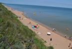
On the islands of the Southern Group ( Saipan, Tinian and Rota)- Beaches with fine white sand. The islands of the Northern Group - the beaches here are with black volcanic sand.
Last modified: 05/10/2013Story
The Mariana Islands were discovered by the expedition of Magellan on March 6, 1521. Chamorro natives, who lived at the stage of the primitive communal system, stole a boat from the Spaniards, and Magellan called these islands Las Islas de los Ladrones - that is, the islands of Thieves or the Robber Islands.
Although these islands were declared possession of Spain in the 16th century, the Spaniards began to establish practical control over them only from 1668. Spanish Jesuit monks landed there, renaming the islands the Marianas, "Las Islas Marianas" or "Las Marianas" in honor of Marianne of Austria, and began the conversion of the natives to the Christian faith. This caused fierce resistance from the natives, and as a result, almost the entire male population of the islands was destroyed by the Spanish soldiers who accompanied the monks. Subsequently, the population of the Mariana Islands increased again due to the offspring of aboriginal women from Spanish soldiers and monks.
The Spanish colonialists practically did not develop the islands, and at the end of the 19th century, Germany became very interested in the Pacific territories. As a result, under an agreement dated February 12, 1899, Germany bought the Mariana Islands from Spain for an amount equivalent to $ 4.5 million (except for Guam, annexed by the United States - the largest and southernmost island of the Mariana Archipelago).
The Germans began to create plantations on the islands, but their dominion was short-lived - during the First World War, the Mariana Islands (like the neighboring Caroline and Marshall Islands, also bought by Germany from Spain in 1899) were occupied by Japan, which, under the Versailles Treaty, received them as a mandate of the League Nations.
The Japanese actively developed plantations of sugar cane, as well as coconut palms, tobacco and citrus fruits on the islands, and pursued a targeted policy of settling the islands by the Japanese and forcibly assimilated the natives (including the method of forced physical mixing of natives with Japanese settlers).
During World War II, American troops captured the Marianas and other pacific islands, after the war, Japanese settlers were deported to Japan, and the Caroline, Marshall and Mariana Islands were transferred under the care of the United States in 1947 by decision of the UN.
The community of the Northern Mariana Islands was created in 1976 in the process of division of the UN Trust Territory of the Pacific Islands. Unlike the Marshall and Caroline Islands, the Marianas decided to abandon state independence, preferring only internal self-government.
On November 4, 1986, the final agreement on the political union of the Northern Mariana Islands with the United States came into force.
In 2007-08, changes were made to the agreement on political union between the Commonwealth of the Northern Mariana Islands and the United States, bringing the laws of the commonwealth closer to US requirements. Including the gradual increase in the minimum wage to the size established in the United States, the election of a delegate to the House of Representatives in the US Congress and changes in immigration laws (the last changes came into effect on November 28, 2009).
Last modified: 05/10/2013Entertainment
Popular in the Northern Mariana Islands are - diving, snorkeling, trekking, windsurfing And golf.
Diving- the main dive site of Saipan "Grotto" (underwater access to the ocean through underwater grottoes) - is the most unique in the world in terms of the beauty of underwater architecture. The water temperature in the coastal waters of the islands is comfortable all year round and does not change depending on the time of day. Perfect transparency allows you to see the beauty of the underwater world.
Snorkeling- the best places for snorkeling: Saipan - Managaha island, Tinian - Tachona beach, Rota - Corell Gardens in Sasanaya Bay.
Trekking- all three main islands of the archipelago are good for hiking. The main route in Saipan is the Laderana-Tangka trail through the Marpi Commonwealth forest. Tinian has an excellent route along the banks of the Cummer and Taga south of San José.
Windsurfing – the best place for surfing - Micro Beach on Saipan.
Golf- Several golf clubs are open on Saipan: Kingfisher Golf Links ("Kingfisher Golf Club"), Coral Ocean Point ("Coral Ocean Point"), Lao Lao Bay Golf Resort(“Lau Lay Bay Golf Club”), Marianas Country Club (“Marianas Country Golf Club”).
The golf courses of the island are very different from each other technically, but they are similar in one thing - beautiful views of the ocean and chic tropical nature. The local clubs require the same punctuality as most clubs in other countries of the world. All clubs require you to dress appropriately for golf. Tops and slippers are not welcome.
The Mariana Islands in the western Pacific Ocean attract travelers with their beauty tropical paradise. A chain of 15 tiny landmasses is located north of the equator, bordering eastern part Philippine Sea. There are two independent state formations on the territory of the archipelago. One of them is called the Commonwealth of the Northern Mariana Islands or simply the Northern Mariana Islands (CMO), the second is Guam.
tropical paradise
The Mariana Islands offer a warm climate, evergreen forests and picturesque lagoons. The archipelago is surrounded by fantastically beautiful and vibrant underwater world promises exciting adventures. In this part of Micronesia, it is warm in summer throughout the year, the atmosphere of cordial hospitality and celebration reigns. Tourists like to go snorkeling, diving, surfing on the islands. Many come to soak up the whites sandy beaches. In hotels on major islands high level services, there are golf clubs, gourmet restaurants.

Where is the archipelago located, how to get there?
The Mariana Islands on the map stretched between the parallels 12 and 21º, they form an arc along 145 ° E. sh. total length about 810 km. In the south, the archipelago borders on the Carolines, and in the north - on the territory. In this territory, the time difference with Moscow is +6 hours. To travel to the Mariana Islands, Russian citizens do not need to apply for a visa if the stay does not exceed 45 days. You can get to the archipelago by plane with one change in cities in the southeast of the mainland. You will need an amount of 1200-1300 US dollars for a flight with 1-2 transfers on the route "Moscow - Mariana Islands". Rest, prices in hotels depend on the city where the tourist chooses. Air transport, ferries, boats and inflatable boats run between the islands of the archipelago.
When is the best time to go? Climate and seasons
Tours to the Mariana Islands are organized all year round, because in all parts of the archipelago summer lasts 12 months a year. The climate is due to the favorable location of the islands between the Tropic of the North and the equator. The tourist season is open all year round, but travelers need to be aware of the differences between dry and wet periods. Temperature conditions during the year are not very diverse - +27 ... +29 ° С (maximum +33 ° С). Precipitation falls on the order of 2000 mm/year. There is a dry period, its duration is 8 months - from December to July. Then comes wet season, which lasts until November. The trade winds at this time bring an abundance of moisture from the ocean, and most of the precipitation falls. In August-November, there is a high probability of typhoons and storms. The water temperature on the beaches almost all year round is +28...+29 °С, only in February and March it drops to +27 °С. The most comfortable months for rest are December-March.

State structure and population
The Northern Mariana Islands is a territory freely associated with the United States and is self-governing. Citizens are considered subjects of the United States but do not vote in national elections. The population of the island of Guam (Marian Islands) has the same rights. Other important information for tourists about the states of the archipelago:
- the administrative center of the SMO - about. Saipan;
- the capital of Guam is the city of Hagatna;
- English is the official language, Chamorro Aboriginal language and Caroline dialects are also used;
- Catholicism is the dominant religion;
- The US dollar is the monetary unit.
The indigenous people have retained their language and traditions associated with cultivating the land, hunting and fishing. People from other territories of Micronesia and the Caroline Islands support cultural heritage their ancestors in the form of national music, dances, crafts and needlework.
History of Chamorro Land
Presumably in the III millennium BC. e. catamarans delivered the first inhabitants of the Mariana Islands to the outskirts of the Philippine Sea from the territory of modern Indonesia. From these ancient seafarers descended the Chamorro people. The name of the archipelago was given by the Spaniards in honor of the actual head of Spain, Marianne of Austria. In 1565, Miguel Lopez de Legaspi annexed the Mariana Islands to the possessions of the Spanish crown. Large-scale colonization began 100 years later and was associated with missionary activities. The population was converted to Christianity and taught to grow cereals and raise cattle.

IN late XIX century, Spain ceded Guam to the United States, along with Puerto Rico and the Philippines, and sold the other Mariana Islands to Germany. Saipan became the center of coconut cultivation for the Germans. Japan in 1914 seized control of the islands of the archipelago, held the territory until the US Navy and the US Army land landing in 1944. From the airport to about. Tinian took off from the plane that dropped the atomic bomb on the Japanese city of Hiroshima on August 6, 1945. At the same time, the UN recognized the US protectorate over Guam, and in 1947, the guardianship of the United States over the northern islands of the archipelago.
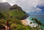
The amazing nature of the islands
The relatively young Mariana Islands on the map represent a chain of land areas of volcanic and coral origin. They arose more than 25 million years ago. In the same part of the ocean, there is the deepest place in the World Ocean - the Mariana Trench with the Challenger Basin (more than 11 km). On the northern island of Agrihan is the highest active volcano in the archipelago (965 m). Soils, flora and fauna were formed under the influence of a warm, humid climate and the proximity of the ocean. Isolation from the mainland also had an impact. The richness of the nature of the large islands is:
- valleys covered with fertile lands;
- rainforests;
- sandy beaches gleaming in the sun.
- majestic cones of extinct volcanoes;
- picturesque underwater caves and grottoes.
Flora includes many types of heat-loving trees, shrubs and flowers. Banana, coconut palm, hibiscus, orchids grow here. Representatives of 40 species of birds live on the islands, giant crabs and pangolins, whose sizes reach 1 m. Among the lush tropical vegetation on the island. Sarigan find shelter wild ungulates.

Tourism on the islands
On about. Saipan is home to 90% of the Commonwealth's population and is the majority beach hotels. The picturesque islands of Tinian and Rota are inhabited, where many hiking trips are organized. tourist routes. The uninhabited parts of the archipelago are also popular due to the opportunity to get to them in one day and practice water sports sports. Travelers go to the islets to watch birds and dive to coral reefs. Saipan has golf courses, excursions around the surrounding area are offered. Tourist favorites include:
- swimming in boats with a transparent bottom;
- yacht cruises;
- windsurfing;
- jungle walks;
- mountain biking through mountains and jungles;
- flights and parachute jumps over the Saipan lagoon;
- attending courses in golf clubs.

Diving, snorkeling and fishing
The coastal waters of the archipelago are clean and transparent. Such conditions are favorable for various forms of living beings.
Dozens of species of coelenterates form the coral reefs that border the Mariana Islands. Photos of the underwater world do not leave indifferent any diver and snorkeler.
Often come across clown fish, tuna, barracuda, swordfish. Dolphins, whales and other sea creatures (octopuses, lobsters, sea turtles) are found in the waters of the ocean near the islands.
Attractions of the archipelago

An abundance of natural conditions for unforgettable holiday complements the developed tourism infrastructure on the large islands - Saipan, Tinyan, Rota and Guam. Popular with fans of water recreation, the coral reef and Lau-Lau Beach are located on the southeast coast of about. Saipan. Grotto is a natural cave with lakes up to 15 m deep and an underwater exit to the azure waters of the Pacific Ocean. In the Marianas, prehistoric latte structures are formed by two parallel rows of slabs. The height is about 1.5 m, the width is over 3.5 m, there are stone ceilings on top. Structures with a length of 12 m could serve as a support for religious buildings or houses. On the island of Tinian is the most famous of these artifacts, called the House of Tag. The eventful history of the Mariana Islands is reflected in museum expositions and memorial monuments.
8 mysteries of the Marianas

Perhaps one of the most mysterious places on the earth map Mariana Islands. This place, which is sometimes referred to as one of the best preserved mysterious corners of America, attracts hundreds of thousands of tourists with its unique nature and many historical sites.
Mariana Islands on the world map

The remoteness of the Mariana Islands from the "mainland" makes them unique place where an atmosphere of peace and absolute carelessness reigns. real paradise for lovers of magnificent panoramas, unique sunsets and crystal clear air.
Where are they?
The Mariana Islands is a small island state, whose territory covers 15 islands of the archipelago of the same name. They are located at the western end of the Pacific Ocean, in a region called micronesia.
Most travelers come here in search of solitude from the noise of megacities and in order to see with their own eyes the monuments of the “Battle of the Pacific” during the Second World War.
The islands of the archipelago are located in such a way that they form two chains with a total length of more than 700 kilometers.
Due to the characteristics of its geographical location Mariana archipelago does not have clear borders with neighboring states. To the south of it are caroline islands (Federated States Micronesia). The conditional natural boundary separating the Philippine Sea from the Pacific Ocean passes at the location of the Mariana Islands.
Relief

Mariana archipelago consists of two chains located from the north and south. In the northern chain, most of the islands are cones formed as a result of volcanic activity over 900 meters high. Note that some of them are small. active volcanoes. The islands in the southern chain are partly volcanic, partly formed by corals.
The nature of the Mariana Islands is typical for the region of the tropics, there are many places where the human foot has hardly set foot. The coral reefs of the Mariana Islands amaze with their splendor and fantastic shapes, and the deepest place on the planet is an 11-kilometer Mariana Trench is located just a few tens of kilometers from the archipelago.
Coastal waters abound with fish, beaches stretch for thousands of meters, and the rich underwater world strives to show all its splendor to diving and snorkeling enthusiasts.
Climate
The climate of the Mariana Islands is characterized as humid, tropical ocean.
The average air temperature in the daytime fluctuates around +28/+33 degrees Celsius, and at night it drops by only a few degrees to +23/+25 degrees.
Humidity quite high and reaches 75-85%. Two seasons are clearly distinguished: in the period from to the wind season begins in this area, and from to the time of typhoons begins.
How to get from Russia?
The easiest way to get here is from some countries in Asia (, Japan, South Korea) or from, therefore, vacationers on the Mariana Islands are dominated by Japanese And Americans.
Due to the remoteness of the Mariana Islands from no direct flights in this direction.
To the airport of the main island of the archipelago - Saipan– can be reached by plane of Asian airlines. Transfers to flights in this direction are carried out in Shanghai, Tokyo or. The duration of such a flight will be about 16 hours, and this is without taking into account flight connections.
Choose plane tickets using this search form. Enter departure and arrival cities, date, number of passengers.
State structure

Picturesque coral reefs, offshore fishing, surfing and diving are all available today in abundance. But not all the time, life seemed like a fairy tale to the inhabitants of the Mariana Islands.
Story
The development of the Northern Mariana Islands took place many centuries ago - around 500 AD, the first settlers appeared here - Chamorro tribes having some kinship with the modern peoples of Polynesia. They were experienced sailors, actively explored the Pacific islands and left behind memorable signs - the famous "latte" stones, whose height could reach 6 meters.
It is curious that some historians see in latte stones some analogy with mysterious statues Easter islands.
European influence on the Mariana Islands began thanks to the legendary navigator Ferdinand Magellan, who was the first European to discover these lands during circumnavigation in 1521. On his ship, he passed through the southern group of islands of the archipelago and named them "Isla de los Ladrones", which in translation meant "Islands of thieves."
The name has been changed to "Las Marianas" in the middle of the 17th century, when the Spanish priest Luis Diego Sanvitores, who found himself in these parts, named them in honor of Queen Anna Maria of Austria.
In 1668, missionaries of the Jesuit order, led by Sanvitores, organized the first mission on the islands, with the advent of which conflicts began between the local population and European colonists. The war lasted two decades, and its result was the eviction of most of the natives on the island of Guam.

In the 19th century resettlement began Spaniards and settlers from the Caroline Islands to the Mariana Islands, gradually began to show interest in the archipelago and. In 1899, Spain sold the Northern Mariana Islands to the German government, which hoped to organize the industrial production of coconut pulp here. However, these plans were corrected by the outbreak of the First World War, and Japan, which turned out to be stronger and more interested, captured the islands.
The Japanese began to grow sugar cane on the islands, cutting down tropical forests and thickets of coconut palms. In the 1930s, the Mariana cane plantations guaranteed the lion's share of Japan's profits.
Dramatic events unfolded in the area of the archipelago in the years Second World War when the archipelago became the site of one of the fiercest and bloodiest battles in the Pacific. US military forces landed on the coast of Saipan in the summer of 1944 and simultaneously attacked the Japanese flotilla.
Thousands of soldiers of both armies became victims of the battle, but the civilian population of the islands suffered the maximum damage.
Subsequently, the United States set up a military airfield here, which was destined to go down in history. It was from this base that two heavy bombers took off into the sky, dropping atomic charges on the Japanese cities of Hiroshima and Nagasaki. With the end of the war, peace came to the islands, they were subordinate to the United Nations, and since 1947 they were influenced by the USA.
Policy

The Mariana Islands are a community with internal self-government. Since 1986, the status of the state has been in effect, "freely joined" to the United States, thanks to which the islands gained local self-government. The United States Custody ended in 1993. The state and the government are simultaneously headed by a governor elected by the population.
On the islands representative presidential democratic system. The main person in the state is the governor. The Marianas are in political union with the United States, and the general funds are managed by a special department within the US Department of the Interior.
Most likely, such an unpleasant ailment as acclimatization will overtake the Mariana Islands. Get ready for it with .
Population
The population of the Mariana Islands archipelago is approximately 700 thousand people. Among them are representatives different nationalities:
- The vast majority of residents are Filipino ethnicity — 34%;
- The second place is occupied by the nationality chamorro -30%;
- On the third Chinese — 12%;
- Close the list micronesians — 8%;
- And people from caroline islands — 5%.
In addition, on the islands of the archipelago live Americans, Japanese, Koreans, Australians.
Religion and language
The official language of the Commonwealth is English. In second place is language of the Chamorro people, as well as an important role caroline, Philippine, Japanese, Korean And Chinese languages.
In the Mariana Archipelago, representatives of each religious group have their own organization and premises for the implementation of rituals.
Main religious movements:
- Catholicism;
- Protestantism;
- Islam;
- local religions and cults.
Numerous activities are taking place here. sects ranging from Mormons to Seventh Day Adventists.
Map of Mariana Islands with cities

Of the 17 islands of the archipelago, only 4 are inhabited: Saipan, Tinian, Rota and Guam.
Capital
The capital of the Mariana Islands is city of Susupe located on the island of Saipan. It is very popular among tourists from and Japan, who come here in large numbers.
Susupe attracts with its unhurried, measured rhythm, the absence of cataclysms and upheavals, which is so important for a modern person.
In Susupa, you can enjoy warm summers all year round and forget about all your worries.
Big cities
- The largest city in the archipelago Garapan located in the western part of the island of Saipan. Most of the administrative buildings on the islands are concentrated here. The city is unique in that its borders are not clearly defined, and almost the entire western coast of the island stretches a chain of small villages and residential buildings surrounded by farms and lush gardens.
- big village Songsong- the biggest locality on the island of Rota. It is located in the southwestern part of the island. The usual city rules do not apply here - residents do just fine without traffic lights and shopping centers. At almost every step you can see all kinds of stones, which are used not only for construction, but also perform the function of marking.
- City hagatna is the administrative center of the island of Guam. It is located on a narrow isthmus that separates the Philippine Sea and the Pacific Ocean. The city was founded in 1668 by the Spaniards, who established the first Jesuit mission on the island. Here you can admire beautiful landscapes and vivid historical monuments.
Watch an informative video about the Mariana Islands: