Crimea today is the blessed land of the Crimean peninsula, washed by the Black and Azov Seas. In the north it stretches a plain, in the south - the Crimean mountains with a necklace near the coastal strip of seaside resort cities: Yalta, Miskhor, Alupka, Simeiz, Gurzuf, Alushta, Feodosia, Evpatoria and seaports - Kerch, Sevastopol.
Crimea is located within 44°23" (Cape Sarych) and 46°15" (Perekop ditch) of northern latitude, 32°30" (Cape Karamrun) and 36°40" (Cape Lantern) of eastern longitude The area of the Crimean peninsula is 26.0 thousand km. the maximum distance from north to south is 205 km, from west to east - 325 km.
A narrow eight-kilometer strip of land to the north (Perekop Isthmus) connects Crimea from the mainland, and 4-5 km - the width of the Kerch Strait in the east (the length of the strait is about 41 km) - separates it from the Taman Peninsula. The total length of the borders of Crimea exceeds 2500 km (taking into account the extreme sinuosity of the coastline of the northeast). On the whole, the coasts of Crimea are little indented, the Black Sea forms three large bays: Karkinitsky, Kalamitsky and Feodosia; The Sea of \u200b\u200bAzov also formed three bays: Kazantip, Arabat and Sivash.
The physical and geographical position of the Crimea as a whole is distinguished by the following most characteristic features. Firstly, the location of the peninsula at 45° north latitude determines its equidistance from the equator and the North Pole, which is associated with a sufficiently large amount of incoming solar energy and a large number of hours of sunshine. Secondly, Crimea is almost an island. This is connected, on the one hand, with a large number of endemics (plant species that are not found anywhere except in a given area) and endemics (similar animal species); on the other hand, this explains the significant depletion of the Crimean fauna; in addition, the climate and other components of nature are significantly influenced by the marine environment. Thirdly, the position of the peninsula in relation to the general circulation of the Earth's atmosphere, which leads to the predominance of westerly winds in Crimea, is of particular importance. Crimea occupies a border position between the temperate and subtropical geographical zones.
Features of the transport and geographical position of the Crimea in the past determined the nature of the population of the peninsula and the specifics of its economy. In the Middle Ages, Crimea was a kind of dead end on the way of many nomadic tribes. Many settled here and adopted the local languages, culture and religion.
The maritime environment of the Crimea determined not only the peculiarities of external economic relations, but also the development of coastal recreation. Through the Danube and Dnieper rivers, Crimea has access to the ports of the countries of Central Europe, the Baltics and Scandinavia, and through the Don and the canal system of European Russia - to the Baltic and White Seas, the Caspian states.
A favorable feature of the economic and geographical position of Crimea is its proximity to the economically developed Kherson and Zaporozhye regions of Ukraine and the Krasnodar Territory of the Russian Federation.
The natural museum is called the nature of the Crimea. There are few places in the world where diverse, comfortable and picturesque landscapes would be so originally combined. In many ways, they are due to the peculiarity of the geographical location, geological structure, relief, climate of the peninsula. The Crimean mountains divide the peninsula into two unequal parts. Large - northern - is located in the extreme south of the temperate zone, southern - the Crimean sub-Mediterranean - belongs to the northern outskirts of the subtropical zone.
The flora of Crimea is especially rich and interesting. Only wild-growing higher plants account for more than 65% of the flora of the entire European part of the Commonwealth countries. Along with this, about 1000 species of alien plants are cultivated here. Almost the entire flora of Crimea is concentrated in its southern mountainous part. This is truly a museum wealth of flora.
The climate of most of the Crimea is the climate of the temperate zone: mild steppe - in the flat part; more humid, typical for broad-leaved forests - in the mountains. The southern coast of Crimea is characterized by a sub-Mediterranean climate of dry forests and shrubs.
Crimea, especially its mountainous part, due to the comfortable climate, the saturation of clean air, toned with phytoncides, sea salts, and the pleasant aroma of plants, also has great healing power. The earth's interior also contains healing mud and mineral waters.
The Crimean peninsula is provided with a large amount of heat not only in summer, but also in winter. In December and January, 8-10 times more heat per unit of the earth's surface per day is received here than, for example, in St. Petersburg. Crimea receives the greatest amount of solar heat in summer, especially in July. Spring here is cooler than autumn. And autumn is the best season of the year. The weather is calm, sunny and moderately warm.
True, sharp fluctuations in pressure during the day exacerbate cardiovascular diseases in people who are not quite healthy. In the Crimea, which is well supplied with heat, the biological productivity of plants, including agricultural crops, and the resistance of landscapes to loads largely depend on the amount of moisture. And the need for water is constantly growing both among the local population and the national economy, primarily rural and resort. So the water in the Crimea is the true engine of life and culture.
A relatively small amount of atmospheric precipitation, a long dry summer, and the spread of karst rocks in the mountains have led to the poverty of Crimea in surface waters.
Crimea is divided into two parts: a flat steppe with a very small number of surface watercourses and a mountainous forest with a relatively dense river network. There are no large fresh lakes here. In the seaside strip of the flat Crimea there are about 50 lake limans with a total area of 5.3 thousand km2.
In Crimea, there are 1657 rivers and temporary streams with a total length of 5996 km. Of these, about 150 rivers are dwarf rivers up to 10 km long. Only the Salgir River has a length of more than 200 km. The river network is developed on the peninsula extremely unevenly.
Depending on the direction of surface water runoff, the division of the Crimean rivers into three groups is accepted: the rivers of the northwestern slopes of the Crimean mountains, the rivers of the southern coast of Crimea, the rivers of the northern slopes of the Crimean mountains.
All rivers of the northwestern slopes flow almost parallel to each other. Approximately up to the middle of their course, they look like typical mountain streams. The largest of them are Alma, Kacha, Belbek and Chernaya.
The rivers of the southern coast of Crimea are short, have very steep slopes of the channels, and a stormy temper in floods.
In the west, in addition to the usually dry ravines and the Khastabash stream, the largest is the Uchan-Su river. Rapidly running to the sea, it forms waterfalls in four places. The highest and largest of them is Wuchang-Su (Flying Water).
The rivers of the northern slopes of the Crimean Mountains are distinguished by the fact that outside the mountains they deviate to the east and flow into the Sivash - the lagoon of the Sea of \u200b\u200bAzov. In the upper reaches of the river there is always water, and within the plains in summer their channels are often dry.
Salgir is the longest river in Crimea. Together with the Biyuk-Karasu tributary, it represents the largest water system in the Crimea. The upper reaches of the Salgir are formed from the confluence of the Angara and Kizil-Koba rivers. Near the village of Zarechnoye, a large tributary of the Ayan flows into the Salgir.
Salgir fills the large Simferopol reservoir, built in 1951-1955. Below Simferopol, the river receives right tributaries - the rivers Beshterek, Zuya, Burulcha, and 27 km from Sivash - Biyuk-Karasu. The Taigan and Belogorsk reservoirs were built on Biyuk-Karasu.
The population of Crimea is distributed unevenly across the territory. 50% of the republic's population lives on the coast. In 1991, 69% of the population lived in cities, and 31% of the population lived in rural areas. 43% of the Crimean population lives in four large cities: Sevastopol (371.4 thousand people in 1991), Simferopol (357 thousand people), Kerch (189.5 thousand people) and Evpatoria (113.3 thousand people).
Crimea is characterized by an increase in the number of cities and urban-type settlements and the relative stability of rural settlements. In recent years, such cities as Sudak, Krasnoperekopsk, Armyansk, Shelkino have appeared on the map of Crimea. The number of urban-type settlements is growing rapidly, more than doubling since 1959.
The main part of the Crimean population is made up of workers (about 60 percent), employees - 28, peasants - less than 11 percent.
Crimea has always been distinguished not only by a high proportion of the urban population, but also by a high level of literacy and education of the inhabitants. For every thousand inhabitants in the cities there were 900, and in the villages 730 people with higher, secondary specialized and secondary education.
The training of highly qualified specialists is carried out by 6 state higher educational institutions (Simferopol State University, Crimean Medical Institute, Crimean Agricultural Institute. Sevastopol Instrument-Making Institute, Crimean Institute of Environmental Protection and Resort Construction. Crimean State Industrial Pedagogical Institute), two branches of universities - Kiev Economic University (in Simferopol) and the Kaliningrad Fish School (in Kerch), as well as several commercial universities.
Military specialists are being trained by the military institute in Sevastopol and the civil engineering school in Simferopol.
In recent years, colleges have been established on a commercial basis. 30 secondary specialized educational institutions are engaged in the training of specialists. Vocational schools train personnel in 120 specialties.
Academic and cultural institutions operate in Crimea. In Simferopol, there is the Crimean branch of the National Academy of Sciences of Ukraine, the production association "Efirmaslo", "KrymNIIproekt", in the village of Nauchny - the Crimean Astrophysical Observatory and others.
There are several professional theaters and a philharmonic society, an art gallery in Feodosia. A large number of newspapers are published. There are publishing houses "Tavrida", "Tavria", "Krymuchpedgiz" and others. There are a large number of museums in Crimea, many of which are connected with the fate of outstanding writers, artists, scientists who lived on the peninsula.
The economic appearance of the Crimea, the structure, the nature of the location of industries and the population evolved mainly in accordance with its natural and socio-economic conditions.
Until 1917, the republic's economy was predominantly agrarian. Gradually, it developed into an industrial-agrarian one.
Crimea stands out for its diversified agricultural and recreational economy, the production of soda ash, titanium dioxide, sulfuric acid, technological equipment for the food industry, televisions, ocean-going ships, fish and fish products. In addition to mechanical engineering, the chemical industry, agriculture and recreation, the food industry also includes the food industry, which produces grape wines, canned fruits and vegetables, and essential oils.
In the structure of industrial production, the leading place belongs to the food industry, followed by mechanical engineering and metalworking, the chemical industry, and the building materials industry.
Crimean agriculture is specialized in grain and livestock breeding, viticulture, horticulture, vegetable growing, as well as in the cultivation of essential oil crops (lavender, rose, sage). The volumes of gross output of livestock and crop production are balanced.
Maritime transport is of great importance for the republic. Through the Crimean ports, export-import transportation of various cargoes is carried out. The most important ports are Kerch, Feodosia, Yalta, Evpatoria. The largest port city is Sevastopol.
By air transport, Crimea is connected with all CIS countries and many far-abroad countries.
Recreational economy is one of the leading branches of the republic. From the Latin language, recreation is translated as “recovery”, meaning the restoration of the physical and psycho-physiological conditions of a person. The structure of the recreational economy includes: sanatoriums, boarding houses, houses and recreation centers, tourist hotels and camp sites, campsites, children's camps. The recreational economy works on beach, balneological and climatic resources, therapeutic mud, sea water, and landscape resources.
The branches of the social infrastructure of Crimea - public utilities, consumer services, public education, public catering, trade, health care, social security, culture, physical education, lending and insurance, science and scientific services - are distinguished by a high level of development.Crimea is not only an administrative and resort unit. First of all, it is a peninsula, a geographical unit. Consequently, in the lessons of the geography of their native land, local students memorize the extreme points of the Crimea - their coordinates, names and features.
Extreme northern point in Crimea
- Coordinates - 46.161050, 33.692249.
It is difficult to name a specific point for this tip of the peninsula - the northern cordon of Crimea runs across the Perekop isthmus. But where is his place? Theoretically right in the middle. Where is his middle?
As a result, geographers took the path of least resistance, issuing a conditional border, indicating that the nearest settlement to the northern point of Crimea was the village of Perekop. It is subordinate to the city council of Armyansk (the city is also located on the isthmus). The settlement was the result of an attempt to restore the town of the same name - it was destroyed during the Civil War. Now about 1000 people live in it, in fact it is a district. Next to it is the border area. But the village itself is not included in it.
As for, it has always been considered the most vulnerable and "responsible" part of the Crimea. It connects it to the mainland, while it is very narrow (no more than 9 km). When trying to attack Taurida from land, Perekop took the brunt of it - for this reason, even in ancient times, it was blocked by defensive structures called. Due to the narrowness of the perimeter, the defense could be held for a long time and reliably - this business was always entrusted to the best military leaders, and the reliable defense of Perekop greatly increased the overall security of Crimea (it is also not easy to take it from the sea).
Of the "warriors of Perekop", the Tatar Murza Tugay-bey (comrade-in-arms of B. Khmelnitsky) and M.V. Frunze, who in 1920 organized a unique military operation to defend the white army of Baron Wrangel.
Extreme point in the south of Crimea
- Coordinates - 44.386747, 33.777032.
With the south, everything is also not easy, the sources call two capes - and Nikolai (both - next to and next to each other).
In fact, the extreme southern point of the Crimea is still Cape Nikolai, but Sarych is 3 geographical minutes to the north. It's just that he is more famous, in particular, for the legendary battle of the Russian squadron with the Breslau and Goeben cruisers at the initial stage of the First World War.

Its name is associated with the name of N.N. Raevsky, general, hero of the Patriotic War of 1812, father-in-law of the Decembrist S.G. Volkonsky. For his military exploits, the commander was granted a country estate near the cape, and the geographical object was named after the patron saint of himself and his father.
Now it is problematic to get to the ledge itself - there is a frontier post on it. Near it camp "Foros" is located.
Extreme point in the west of Crimea
- Coordinates - 45.390415, 32.480458.
The extreme western point of Crimea will not provide a comfortable rest - the shores of Cape Priboyny (the Tatar name Kara-Mrun is also common) are steep, there are no tolerable roads on its plateau.

But it is located in a romantic resort area - it is part of the Tarkhankut Peninsula. The nearest settlement to it is popular. Surfing delimits and . From the north, its neighbor is Ocheretai Bay, also known among tourists.
A geodetic sign has been installed on the cape. Its plateau is covered with the usual annual meadow herbs and, in principle, is not very interesting. Usually regulars wander here to take pictures "in the very west of Crimea."
Extreme eastern point in Crimea
- Coordinates - 45.382946, 36.644643.
But not all extreme points of Crimea are so mysterious or everyday. Its eastern end - - has a clear location on the map, a rich and, moreover, well-studied history, and no one disputes its right to be called the "border".
The cape is found on, near the outskirts of modern Kerch and marks the entrance to. For this reason, it has been marked by people since ancient times. Archaeologists have documented the existence of settlements of the Bronze Age and the ancient Greek settlement Parthenium on Lantern.
There is an active lighthouse on the cape. It appeared there in 1820, but now you can see only new buildings - the old ones were destroyed during the Great Patriotic War (the participants of the Kerch-Eltingen operation were disembarked here). The lighthouse complex still does not guarantee against crashes - in 1995, the cargo ship "Doja" under the Syrian flag sank abeam Lantern - the now abandoned ship is a bait
The Republic of Crimea occupies the territory of the Crimean peninsula.
The territory of the Republic of Crimea is 26.1 thousand square meters. km.
Length: from west to east - 360 km, from north to south - 180 km.
Extreme points: in the south - Cape Sarych; in the west - Cape Priboyny; in the east - Cape Lantern.
The most important seaports are Evpatoria, Yalta, Feodosia, Kerch.
Adjacent regions: Krasnodar region of the Russian Federation, Kherson region of Ukraine.
The climate of the peninsula differs in its various parts: in the northern part it is temperate continental, on the southern coast with features of the subtropical. Crimea is characterized by a small amount of precipitation throughout the year, a large number of sunny days, and the presence of breezes on the coast.
The relief of the Crimean peninsula consists of three unequal parts: the North Crimean Plain with the Tarkhankut Upland (about 70% of the territory), the Kerch Peninsula and in the south - the mountainous Crimea extends in three ridges. The highest is the Main Ridge of the Crimean Mountains (1545 m, Mount Roman-Kosh), consisting of individual limestone massifs (yayl) with plateau-like peaks and deep canyons. The southern slope of the Main Ridge stands out as the Crimean sub-Mediterranean. The Inner and Outer ridges form the Crimean foothills.
The Crimean peninsula is washed by the Black and Azov seas.
The natural reserve fund includes 158 objects and territories (including 46 of national importance, the area of which is 5.8% of the area of the Crimean peninsula). The reserve fund is based on 6 nature reserves with a total area of 63.9 thousand hectares: Crimean with the Lebyazhy Islands branch, Yalta Mountain Forest, Cape Martyan, Karadagsky, Kazantipsky, Opuksky.
Crimea is a peninsula rich in natural resources. In its depths and on the adjacent shelf there are industrial deposits of iron ore, combustible gas, mineral salts, building materials, oil and gas condensate.
Of greater importance are the natural recreational resources of the peninsula: mild climate, warm sea, therapeutic mud, mineral waters, picturesque landscapes.
The largest rivers are Salgir, Indol, Biyuk-Karasu, Chornaya, Belbek, Kacha, Alma, Bulganakh. The longest river in Crimea is Salgir (220 km), the most full-flowing is Belbek (water flow rate is 1500 liters per second).
There are more than 50 salt lakes in Crimea, the largest of them is Lake Sasyk (Kunduk) - 205 sq. km.
The population of Crimea as of January 1, 2013 is 1 million 965.2 thousand people. Including the economically active population is 970.3 thousand people, or less than 50% of the total population.
About 130 ethnic groups live in the Republic of Crimea. The largest ethnic groups are Russians (58.3%), Ukrainians (24.3%) and Crimean Tatars (12.1%).
Official languages: Russian, Ukrainian, Crimean Tatar.
Time zone: MSK (UTC+4).
Administrative-territorial structure: cities of republican significance - 11, districts - 14.
The capital of the Republic of Crimea is the city of Simferopol.
The representative body of the Republic of Crimea is the State Council of the Republic of Crimea.
The executive body of the Republic of Crimea is the Council of Ministers of the Republic of Crimea.
The Republic of Crimea has symbols: coat of arms, flag and anthem.
Crimea has long been rightly called the natural pearl of Europe. Here, at the junction of temperate and subtropical latitudes, as if in focus, the characteristic features of their nature are concentrated in miniature: mountains and plains, ancient volcanoes and modern mud hills, seas and lakes, forests and steppes, landscapes of the Black Sea sub-Mediterranean and semi-deserts of the Sivash region ...
The Crimean Peninsula is located in southern Russia at the latitude of southern France and northern Italy.
His outlines peculiar, some see them as a flying bird, others - a bunch of grapes, others - a heart.
But each of us, looking at the map, immediately finds in the middle of the blue oval of the sea an irregular quadrangle of the peninsula with a wide ledge of the Tarkhankut Peninsula in the west and a long, narrower ledge of the Kerch Peninsula in the east. The Kerch Strait separates the Crimean Peninsula from the Taman Peninsula, the western tip of the Krasnodar Territory.
Crimea, washed almost from all sides by the waters of the Black and Azov Seas, could be an island, if not for the narrow, only 8 kilometers wide, Perekop Isthmus, connecting it with the mainland.
The total length of the borders of Crimea– more than 2500 km.
Square- 27 thousand square meters. km.
Max distance from north to south is 207 km, from west to east - 324 km.
Extreme points: in the north - the village of Perekop (46°15' north latitude), in the south - Cape Sarych (44°23' north latitude), in the east - Cape Lantern (36°40' east longitude), in the west – Cape Kara-Mrun (32°30′ E long.).
Water Black Sea(area - 421 thousand sq.
sq. km, volume - 537 thousand cubic km) wash the Crimea from the west and south. The largest bays are Karkinitsky, Kalamitsky and Feodosia.
From the east and northeast, the peninsula is surrounded by the Kerch Strait (width 4-5 km, length 41 km) and Sea of Azov(area - 38 thousand sq. km, volume - 300 cubic km), which forms the Kazantip, Arabat and Sivash bays.
coastpeninsulas heavily indented by numerous bays, coves and bays.
Crimean mountains divided the peninsula into two uneven parts: a large steppe and a smaller mountain.
They stretched from the southwest to the northeast from the vicinity of Sevastopol to Feodosia in three almost parallel ridges separated by longitudinal green valleys. The Crimean Mountains are about 180 km long and 50 km wide.
The main ridge is the highest, the most famous mountain peaks are located here: Roman-Kosh - 1545 m, Chatyrdag - 1525 m, Ai-Petri - 1231 m.
The southern slopes facing the sea are steep, while the northern slopes are steep.
The peaks of the Crimean Mountains are treeless, undulating plateaus called yayls (translated from Turkic means "summer pasture"). Yayly combine the properties of plains and mountains. They are connected by narrow low ridges, along which mountain passes pass. The paths from the steppe part of the Crimea to the Southern coast have long run here.

The beginning of the ascent to the Devil's Stairs pass, an ancient road that leads from the forest regions of the mountainous Crimea to the South Shore.
The highest yayls of Crimea: Ai-Petrinskaya (1320 m), Yalta (1406 m), Nikitskaya (1470 m), Gurzufskaya (1540 m).
The limestone surface of the yayla has been dissolved by rainwater for many centuries, water flows have made numerous passages in the thickness of the mountains, deep wells, mines, caves of amazing beauty.
The inner ridge of the Crimean mountains is lower than the Main one (the highest point - Mount Kubalach reaches 739 m). It stretched from the Mekenziev mountains near Sevastopol to Mount Agarmysh for 125 km.
The outer, or Northern, ridge is even lower - from 150 to 340 m, it is called the foothills.
The rocks of which it is composed lie at an angle: the southern slopes break off with steep cliffs, and the northern ones are gentle, long, gradually turning into a plain.
Steppe occupies a large territory of the Crimea. It represents the southern outskirts of the East European, or Russian, plain and slightly lowers to the north. The Kerch Peninsula is divided by the Parpach Ridge into two parts: the southwestern - flat and the northeastern - hilly, which is characterized by the alternation of ring-shaped limestone ridges, gentle depressions, mud hills and coastal lake basins.
However, mud volcanoes have nothing in common with real volcanoes, as they erupt not hot lava, but cold mud.
In the flat part of the peninsula, varieties of southern and carbonate chernozems predominate, dark chestnut and meadow chestnut soils of dry forests and shrubs, as well as brown mountain-forest and mountain-meadow chernozem-like soils (on yayles) are less common.
More than 52% of the territory of the republic is occupied by arable land, 4.7% - by orchards and vineyards.
The remaining lands are predominantly pastures and forests.

The expanses of Crimea
Square forests reaches 340 thousand.
ha. The slopes of the Crimean Mountains are occupied mainly by oak forests (65% of the area of all forests), beech (14%), hornbeam (8%) and pine (13%).
On the southern coast in the forests grow relic high juniper, evergreen small-fruited strawberry, pistachio tupolis, a number of evergreen shrubs - Pontic needle, Crimean cistus, red pyracantha, shrub jasmine, etc.
On the peninsula 1657 rivers and temporary drains.
Their total length is 5996 kilometers. However, the vast majority of them are small, in summer almost all watercourses dry up. There are only 257 rivers longer than 5 km.
The most significant of the rivers, according to their geographical position, are divided into several groups: the rivers of the northern and northeastern slopes of the Crimean Mountains (Salgir, the longest river of the peninsula, - 232 km; Wet Indol - 27 km; Churuksu - 33 km, etc.); rivers of the northwestern slope (Chernaya - 41 km, Belbek - 63 km, Kacha - 69 km, Alma - 84 km, Western Bulganak - 52 km, etc.); the rivers of the southern coast of Crimea (Uchan-Su - 8.4 km, Derekoika - 12 km, Ulu-Uzen - 15 km, Demerdzhi - 14 km, Ulu-Uzen East - 16 km, etc.); river-beams of the flat Crimea and the Kerch Peninsula.
The rivers of the northwestern slopes of the Crimean Mountains flow almost parallel to each other, until the middle of the course they are typically mountainous.
The rivers of the northern slopes on the plain deviate to the east and flow into the Sivash. The short rivers of the Southern Coast flowing into the Black Sea are typically mountainous throughout their entire length.
The mountain river Wuchang-Su runs down to the sea, forming waterfalls in four places.

Crimea. Baidarsky reserve. Kozyrek waterfall during the snowmelt period (left).
One of the tributaries of the Black River during high water (on the right).
The main source of river nutrition is rainwater - 44-50% of the annual runoff; groundwater provides 28-36% and snow nutrition - 13-23%. The average long-term surface and underground runoff of the Crimea is a little over 1 billion cubic meters. water. This is almost three times less than the volume of water that annually enters the peninsula through the North Crimean Canal. The natural reserves of local waters are used to the limit (73% of the reserves are used).
The main surface runoff is regulated: several hundred ponds and more than 20 large reservoirs have been built (Simferopol on the Salgir River, Chernorechenskoye on the Chernaya River, Belogorskoye on the Biyuk-Karasu River, etc.).
Through the North Crimean Canal, 3.5 billion cubic meters of gas is supplied to the peninsula annually.
cubic meters of water, which made it possible to increase the area of irrigated land from 34.5 thousand hectares (1937) to 400 thousand hectares (1994).
In Crimea, mainly along the coasts, there are more than 50 estuary lakes with a total area of 5.3 thousand square meters. km used to obtain salts and therapeutic mud: Saki, Sasyk, Donuzlav, Bakal, Old, Red, Aktash, Chokrak, Uzunlar, etc.
Sources:
All about the Crimea: Reference and information publication / Under the general.
ed. D.V. Omelchuk. - Kharkov: Caravel, 1999.
Yena V.G. Nature of Crimea // Crimea: present and future: Sat. articles - Simferopol: Tavria, 1995.
In this article, we will tell you about Crimea peninsula. Despite the fact that in recent years more and more tourists flock to rest on the Mediterranean coast of Turkey, as well as on the tropical islands of Thailand.
However, Crimea still remains a popular holiday destination for hundreds of thousands of people. Foreign tourists, first of all, visit the capital city of Ukraine - Kyiv, which has many historical and architectural sights.

Peninsula Crimea and the Sea of Azov. View from space
In addition, in the city of Kyiv, you can use the Internet directly in the parks.
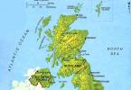
Crimea Map
And if one of the tourists did not take his tablet computer on a trip, then he can buy a Kiev laptop at an affordable price in numerous FoxMart stores in the city, which offer a wide range of laptops from various world famous brands, such as: SAMSUNG, ACER, LENOVO, ASUS, HP, SONY and some others.
Thanks to the Internet and a laptop, you can learn a lot of necessary, useful and, of course, interesting information, for example, about the Crimean peninsula.
Peninsula Crimea located in the southern part of the Republic of Ukraine. Geographically Crimea The Russian peninsula belongs to the Northern Black Sea region.
On the peninsula Crimea located Autonomous Republic Crimea, the city of Sevastopol, as well as part of the Kherson region. Peninsula Crimea in the documents of the Russian Empire until the 20s of the XX century it was called Tauris.
After the creation of the Soviet Union, the Taurida Peninsula was renamed and received the name " Crimea».
Toponym " Crimea” probably comes from the Turkic word “kyrym”, which literally means a rampart, wall, ditch.
The Crimean peninsula is washed by: in the west and south - the Black Sea, from the east - the Sea of \u200b\u200bAzov, including the Sivash Bay. Peninsula Crimea deep into the Black Sea.
The area of the Crimean peninsula is approximately 26,860 km², of which 72% is a flat surface, 20% is occupied by Crimea mountains, 8% are water bodies - lakes, rivers.
The length of the coastline of the peninsula Crimea is over 1000 km.
The total length of the sea and land borders of the peninsula Crimea is over 2500 km.
The greatest length Crimea of the peninsula in the direction from west to east between the picturesque capes Kara-Mrun and Lantern is approximately 325 km, and in the direction from north to south from the narrow Perekop Isthmus to Cape Sarych is 205 km.
There are the largest bays on the Black Sea coast: Karkinitsky Bay, Kalamitsky Bay, Feodosiya Bay.
On the coast of the Sea of Azov there are the following bays: Sivash Bay, Kazantip Bay and Arabat Bay.
in the east Crimea peninsula between the Black Sea and the Sea of Azov is the Kerch Peninsula, and in the west the tapering part Crimea and forms a relatively small Tarkhankut Peninsula.
In the northern part of the peninsula Crimea It is connected to the mainland by a rather narrow Perekop isthmus, the width of which at its widest point does not exceed 8 km.
Peninsula Crimea according to the nature of the relief, it is divided into platform-flat, which occupies 70% of the entire territory, the rest falls on the folded-mountain surface. On the southern part of the peninsula Crimea sprawled beautiful Crimea sky mountains. The highest mountain of the peninsula Crimea- Mount Roman-Kosh, which reaches a height of 1545 meters above sea level.
Extreme northern point Crimea The southernmost point of the peninsula is located on the Perekop Isthmus, its extreme southern point is the beautiful Cape Sarych, the extreme western point is Cape Kara-Mrun (Priboyny) on the Tarkhankut Peninsula, the extreme eastern point of the peninsula is Cape Lantern on the Kerch Peninsula.

The picturesque nature of the Crimean peninsula
Crimea is a popular seaside resort located in southwestern Russia. The main reasons why people tend to the peninsula are: the sea and mountains. Crimea It is washed by two seas: Black and Azov. Most of the resorts are located on the south coast, whose climate is comparable to the Cote d'Azur.
Crimea: the history of the name of the peninsula
There are several versions of the origin of the name of the peninsula: from the Turkic " Crimea” translates as “ditch”.
Another version says that the name comes from the city of Kyrym, the former residence of the Golden Horde governor and became popular in the 13th century. This name was not the first for the peninsula - others are known in history:
- Taurica is the ancient name of the peninsula, descended from the tribe of Taurians who previously inhabited these places.
- Tavria is a name that came into use in the 15th century.
- Taurida - came into use since 1783, when the peninsula became part of the Russian Empire.

Also Crimea in different years was identified with Cimmeria and Lesser Scythia.
During the years of Soviet power, the Crimean region existed, after Ukraine gained independence - the Autonomous Republic of Crimea, and since 2014, the Republic of Crimea has appeared as part of Russia.
The geographical position of the Crimea briefly
Crimea is washed from the east by the Sea of Azov, from the south and west by the Black Sea, and in the north of the peninsula is the salty Sivash Bay. Most of the territory of the peninsula is located in the temperate zone, and the South Coast is in the subtropical zone, thus providing an advantageous geographical position of Crimea like a resort.
The peninsula is divided into 3 conditional parts: steppe, mountains, southern coast. Extreme points of Crimea:
- north - Perekop isthmus;
- south - Cape Sarych (located at 44°23′14″ N);
- west - Cape Priboyny;
- east - Cape Lantern.

The highest point is Roman-Kosh (1545 meters), located on Babugan-yayle.
18 settlements in Crimea have city status. The most populated among them are Sevastopol, Simferopol and Kerch. The main resorts are Yalta, Alushta and Evpatoria.
The area of Crimea is 27 thousand km².
Cape Sarych - the southernmost point of Crimea
The capital of Crimea is Simferopol, whose name translates as "collector city".
History of Crimea
Since ancient times, the peninsula has been the scene of hostilities. Many nomadic tribes came here, then giving way to stronger ones. That's why history of Crimea contains many bloody pages and kept them in her legends and traditions.
The first settlers of the peninsula in the Middle Paleolithic were Neanderthals, whose sites were found in several places: Kiik-Koba, Chokurcha (considered the oldest human dwelling in Europe).
A little later, in the Mesolithic, the Cro-Magnons appeared here.
Later, these places were settled by the Cimmerians in the XII century BC. e., as well as Taurians and Scythians who came to these lands in the 7th century BC.
e. Later, Greek settlers came to the lands of Taurida, organizing many cities on the coast and starting trade with the local population. This is how the Kingdom of Bosporus, Chersonese, Kerkinitida and a number of other cities appeared.
 The Goths, Huns, Khazars, Byzantines, Tatars, Genoese, Turks left their mark here.
For a long time (1441 - 1783) the Crimean Khanate with its capital in Bakhchisarai was located here.
Most of the time it was under the rule of the Ottoman Empire, and after passing under the rule of Russia, the khanate was disbanded.
In 1475, these lands were captured by the Ottoman Empire, which defeated both the Genoese and the mountainous principality of Theodoro. The Turks ruled here for 3 centuries, but in 1774 Prince Dolgoruky annexed Taurida to the Russian Empire.
Before 1954 Crimea was part of Russia until it was transferred to the Ukrainian SSR.
In 2014, the peninsula returned to Russia again.

The peninsula is full of unusual, interesting and mysterious. I invite you to know some interesting facts about Crimea:

You can learn more about Crimea on other pages of our site.
Where is Crimea located?
Where is Crimea located on the map of Russia? The Crimean peninsula is located in the northern part of the Black Sea, and from the northeast it is washed by the Sea of Azov. In the north of Crimea, it is connected with the mainland Perekop Isthmus (the bay).
Now, of course, many Russians are interested and curious to know how long it takes to fly to Crimea from different cities in Russia, because the Crimean peninsula has become part of the Russian Federation and is likely to break the flow of tourists here.
On a detailed map of the Crimean coast, you can see that the entire coastline stretches for 2.5 thousand kilometers.
It is also interesting that on the Black Sea coast the main resort cities are Sochi and Abkhazia, which are competitors of Crimea in terms of tourism, so it is recommended to read an interesting article about comparing these places for the quality of recreation and leisure - if it is better to relax: in Sochi or in Crimea?
There are many mountain peaks on the peninsula, of which the highest is Rimsko-Kosh, 1545 meters high.
The northernmost point of the peninsula is the Perekop Strait, to the south - on Cape Miklavts, in the west - in Cape Kara-Mran, in the east - in the cape, on the Kerch Peninsula.
Geography of Crimea
The northern channel is the largest on the peninsula.
 Detailed map of the Crimean coast
In Yandex and Google, you can find a detailed map of Crimean cities and cities where the most popular settlements on the peninsula will be defined as Yalta, Alushta, Alupka, Feodosia, Dzhalta, Sudak and others.
Sevastopol is a heroic city with many sights during World War II. The most famous natural and historical attractions are the Crimean caves: marble, red and Emine-Bayr-Khosar cave.
 Map of cities and places
What is Crimea
climate and natural areas of Crimea
Answers:
Crimea, despite its relatively small territory, has a diverse climate. The climate of Crimea is divided into three subzones: Steppe Crimea (most of Crimea, north, west and center of Crimea). Crimean Mountains Southern coast of Crimea The climate of the northern part is temperate continental, on the southern coast - with features similar to subtropical.
The average temperature in January is from -1 ... -3 ° C in the north of the steppe zone to +1 ... -1 ° C in the south of the steppe zone, on the southern coast of Crimea from +2 ... + 4 ° C. The average July temperature of the South Coast and the eastern part of Crimea: Kerch and Feodosiya is +23…+25 °C. Precipitation varies from 300-400 mm per year in the north to 1000-2000 mm in the mountains. In summer (in the second half of July) in the steppe part of Crimea, the daytime air temperature reaches +35…+37 °C in the shade, at night up to +23…+25 °C.
The climate is predominantly dry, seasonal dry winds prevail. The Black Sea warms up to +25 °С in summer. The Sea of Azov warms up to +27…+28 °С. The steppe part of Crimea lies in the steppe zone of the temperate climate. This part of the Crimea is characterized by long dry and very hot summers and mild, little snowy winters with frequent thaws and very changeable weather.
The Crimean Mountains are characterized by a mountain type of climate with pronounced zonality in height. Summers are also very hot and dry, while winters are wet and mild. The southern coast of Crimea is characterized by a sub-Mediterranean climate.
Snow cover is only temporary, it is established on average once every 7 years, frosts only during the passage of the Arctic anticyclone.